📄 Exam Questions & Readable Text Transcript
Full OCR-extracted text of questions, syllabus codes, and exam instructions.
Extracted Content: 60371 Physical Geography
Page 1
Extracted Text
Tor PZIMBABWE SCHOOL EXAMINATIONS COUNCIL
General Certificate of Education Advanced Level
GEOGRAPHY 6087/1
PAPER 1
3 hours
Additional materials:
Answer paper
TIME 3 hours
INSTRUCTIONS TO CANDIDATES
Write your name, Centre number and candidate number in the spaces provided on the answer
paper/answer booklet.
Answer any four questions in this paper.
Write your answers on the separate answer paper provided.
If you use more than one sheet of paper, fasten the sheets together.
INFORMATION FOR CANDIDATES
The number of marks is given in brackets [ ] at the end of each question or part question.
Sketch maps and diagrams should be drawn wherever they serve to illustrate an answer.
Y ou are reminded of the need for good English and clear presentation in your answers.
This question paper consists of 4 printed pages.
Copyright: Zimbabwe School Examinations Council, Specimen Paper.
©ZIMSEC SPECIMEN PAPER
---
Page 2
Extracted Text
@Altitude
in
meters
b)
(ao)
2
Answer any four questions.
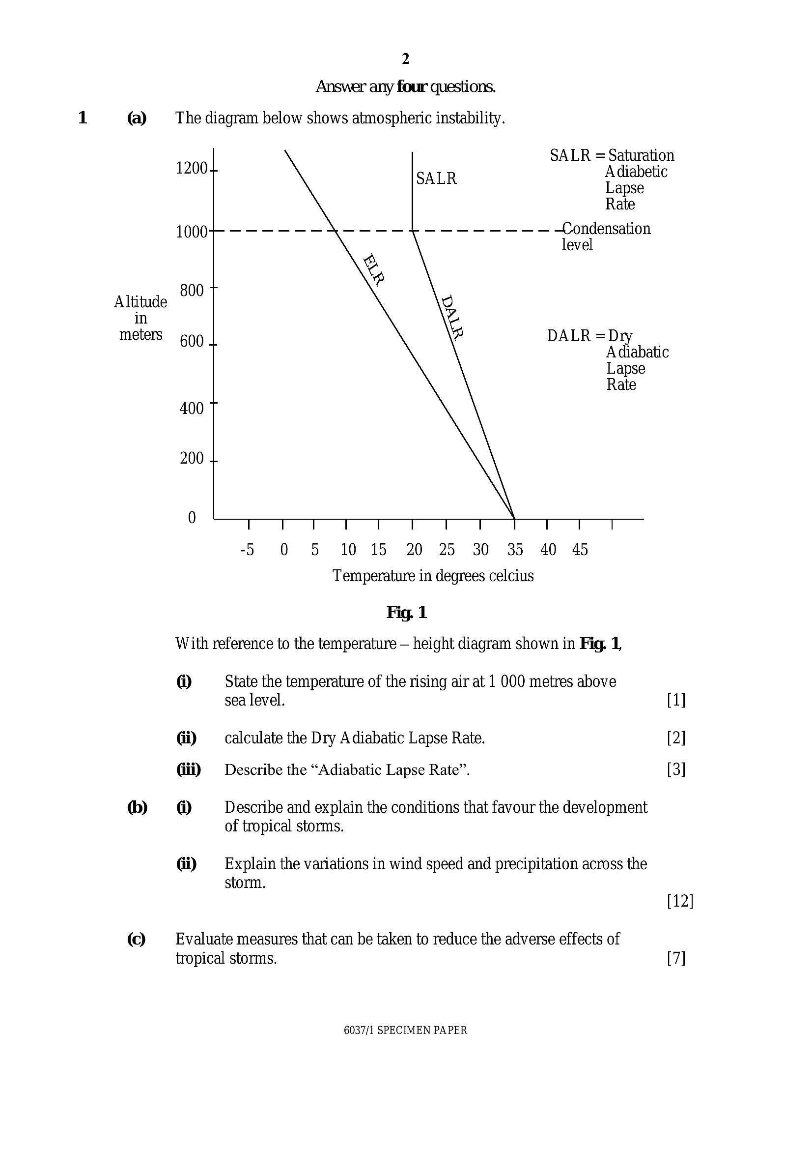
The diagram below shows atmospheric instability.
SALR = Saturation
1200+ Adiabetic
Lapse
Rate
1000+ - -----—----+-------- —Condensation
level
800 T
DALR =Dry
600 + Adiabatic
Lapse
Rate
400 7
200 +
0 eS To
5 0 5 10 15 20 25 30 35 40 45
Temperature in degrees celcius
Fig. 1
With reference to the temperature — height diagram shown in Fig. 1,
@ State the temperature of the rising air at 1 000 metres above
sea level. [1]
Gi) calculate the Dry Adiabatic Lapse Rate. [2]
Gii) Describe the “Adiabatic Lapse Rate”. [3]
@ Describe and explain the conditions that favour the development
of tropical storms.
Gi) —_— Explain the variations in wind speed and precipitation across the
storm.
[12]
Evaluate measures that can be taken to reduce the adverse effects of
tropical storms. [7]
6037/1 SPECIMEN PAPER
---
Page 3
Extracted Text
@ b)@
b)
(ao)
@)
b)
(ao)
@)
)
(ao)
@)
)
(ao)
@)
)
(ao)
3
Draw a labelled diagram to show a rift valley.
Outline the benefits and problems of fold mountains to the local
community.
How may human activities modify slope forms.
Briefly describe ‘evaporation’ and infiltration’.
Outline indigenous methods used to test for the presence of water and its
quality.
Explain how man may influence the rate of infiltration.
Describe the characteristics of vegetation in a Tropical Continental
woodland.
Outline the challenges faced in trying to conserve the Tropical
Continental ecosystem.
Assess the success of measures taken to improve soil quality.
Describe the causes of drought,
Write an explanation account of the effects of drought on the
environment.
Explain any three ways in which the effects of drought can be reduced.
Describe the process of scarp retreat as it occurs on slopes.
With the aid of diagrams show how alternating periods of deep weathering
and removal of the resultant layers in the past may have influenced the
formation of bomhardts.
Explain how human activities modify bornhardts in the tropics.
Briefly describe the processes of “percolation” and “throughflow”.
With the aid of annotated diagrams, explain how the shape of river
Hydrographs is influenced by vegetation and rock type.
Explain how people have been responsible for the modification of ground
water stores.
6037/1 SPECIMEN PAPER
6]
12]
7]
6]
12]
7]
6]
12]
6]
12]
6]
12]
7]
6]
12]
7]
---
Page 4
Extracted Text
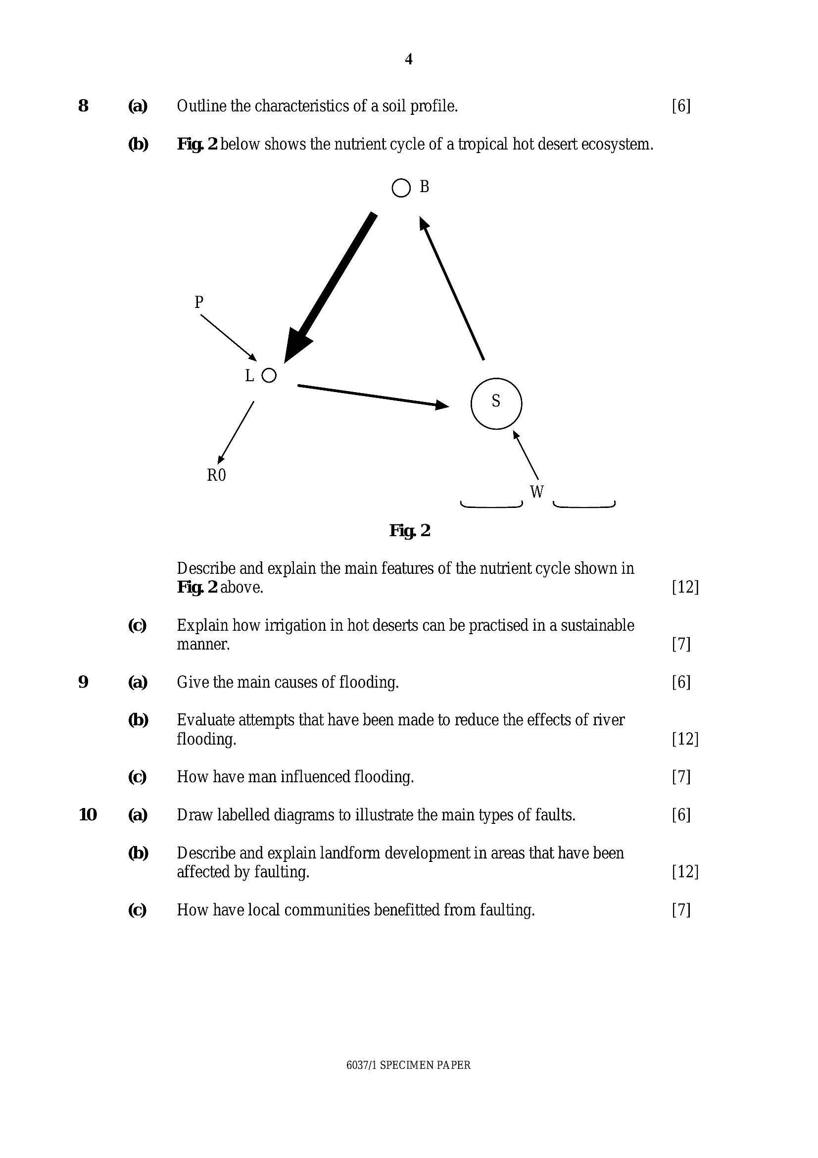
8 (a) Outline the characteristics of a soil profile.@®) Fig. 2below shows the nutrient cycle of a tropical hot desert ecosystem.
OB
é \
Fig. 2
Describe and explain the main features of the nutrient cycle shown in
Fig. 2 above.
© _ Explain how irrigation in hot deserts can be practised in a sustainable
manner.
9 (a) Give the main causes of flooding.
&®) Evaluate attempts that have been made to reduce the effects of river
flooding.
(Co) How have man influenced flooding.
10 @) __ Draw labelled diagrams to illustrate the main types of faults.
&) Describe and explain landform development in areas that have been
affected by faulting.
(Co) How have local communities benefitted from faulting.
6037/1 SPECIMEN PAPER
12]
7]
6]
12]
7]
6]
12]
7]
---
Struggling with the concepts in this paper?
Revise syllabus notes, key exam points, and interactive practice questions for Physics: