📄 Exam Questions & Readable Text Transcript
Full OCR-extracted text of questions, syllabus codes, and exam instructions.
Extracted Content: 40222 Gography
Page 1
Extracted Text
ZIMBABWE SCHOOL EXAMINATIONS COUNCILGeneral Certificate of Education Ordinary Level
GEOGRAPHY 4022/2
PAPER 2
SPECIMEN PAPER 2 hours 30 minutes
Additional materials:
Answer paper
TIME 2 hours 30 minutes
INSTRUCTIONS TO CANDIDATES
Write your name, centre number and candidate number in the spaces provided on the answer
paper/answer booklet.
Answer four questions.
Answer one question from each of Sections A, B and C and one other question from any section.
Write your answers on the separate answer paper provided.
If you use more than one sheet of paper, fasten the sheets together.
INFORMATION FOR CANDIDATES
The number of marks is given in brackets [ ] at the end of each question or part question.
Sketch maps and diagrams should be drawn whenever they serve to illustrate an answer.
This specimen paper consists of 12 printed pages.
Copyright: Zimbabwe School Examinations Council, Specimen Paper.
©ZIMSEC SPECIMEN PAPER [Turn over
---
Page 2
Extracted Text
Section A Physical Environment Answer at least one question from this section.1 (a) @ Describe the characteristics of the tropical continental air mass and
the polar maritime air mass.
[5]
di State two winds that bring widespread rainfall to Zimbabwe.
[2]
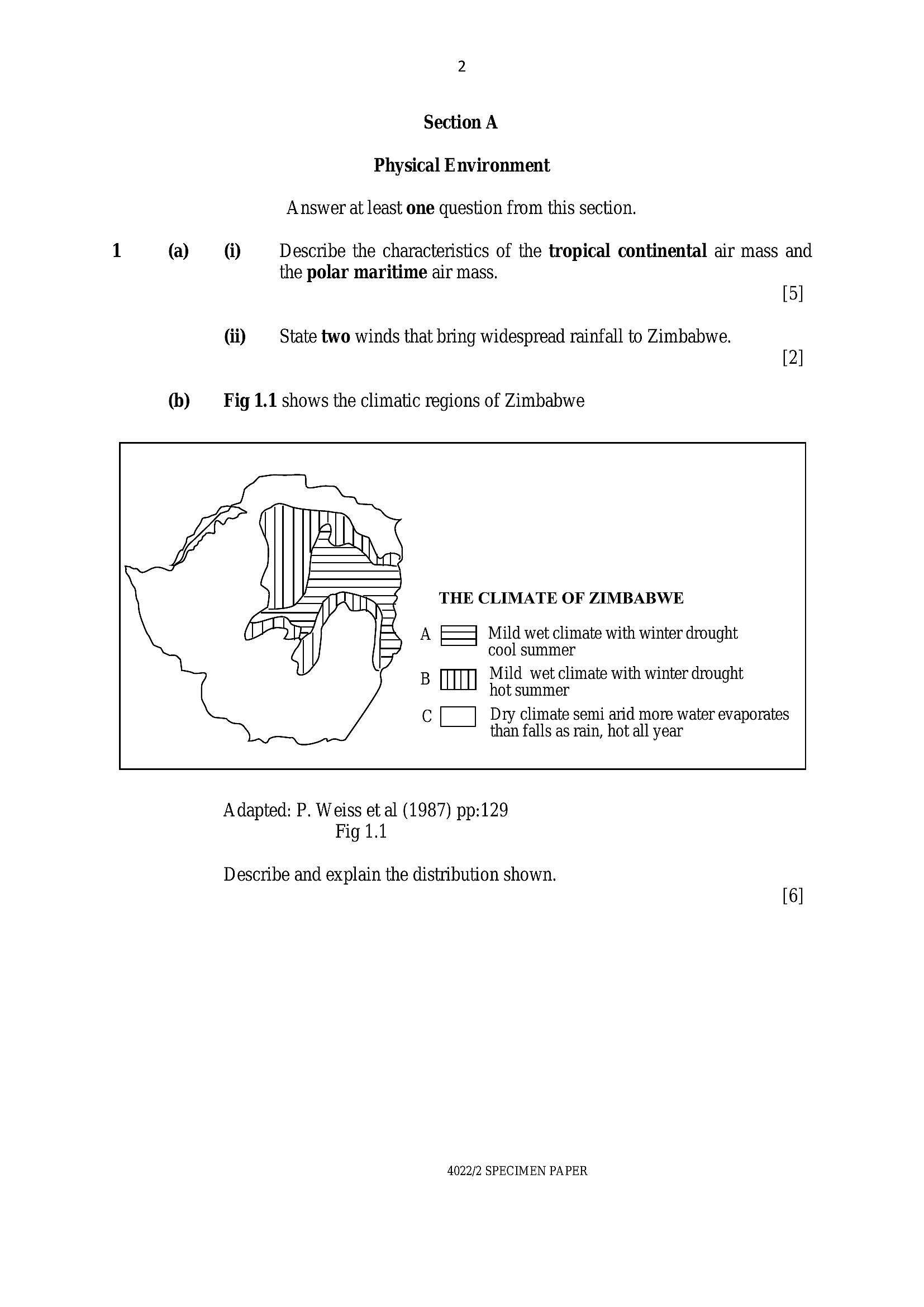
(b) Fig 1.1 shows the climatic regions of Zimbabwe
THE CLIMATE OF ZIMBABWE
A EF} Mild wet climate with winter drought
cool summer
Mild wet climate with winter drought
B (TH hot summer
Cc Dry climate semi arid more water evaporates
than falls as rain, hot all year
Adapted: P. Weiss et al (1987) pp:129
Fig 1.1
Describe and explain the distribution shown.
4022/2 SPECIMEN PAPER
---
Page 3
Extracted Text
(©) Photograph 1.1 shows a human activity. (Provided on Printers’ copies) @ Describe how the activity affects the weather. [5] (ii) | Suggest possible solutions to the problems you mentioned in c(i) above. [7] @ @ State three types of faults. [3] (i)Describe one landform produced by faulting.
[4]
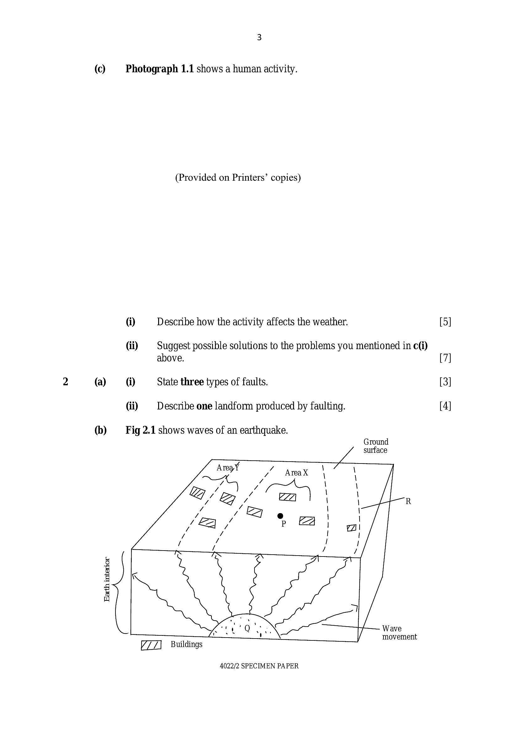
(b) Fig 2.1 shows waves of an earthquake.
Ground
surface
ae 7 wreaX \ \
too \ \
e/a /B / ZZ \ \ R
ae) e | \
7 i
ff = / P a
i
/ /
g Al ray
Bk
4
_ a Wave
movement
Buildings
4022/2 SPECIMEN PAPER
---
Page 4
Extracted Text
© (a)(b)
[Turn over
@ Identify and describe parts P, Q and R. [6]
di Which of the areas X and Y will experience massive destruction
as a result of an earthquake? Give reasons. [5]
Suggest the benefits of faulting to people. [7]
@ State the metamorphic rocks formed from each of the following
rocks:
granite,
coal,
limestone,
basalt.
(ii) = Name the rock type with following characteristics:
Forms hard resistant layer of the Victoria Falls.
Forms the gold belts within granite zones scattered in Zimbabwe.
A mineral storehouse of Zimbabwe centrally positioned feature
stretching from North to South direction.
[3]
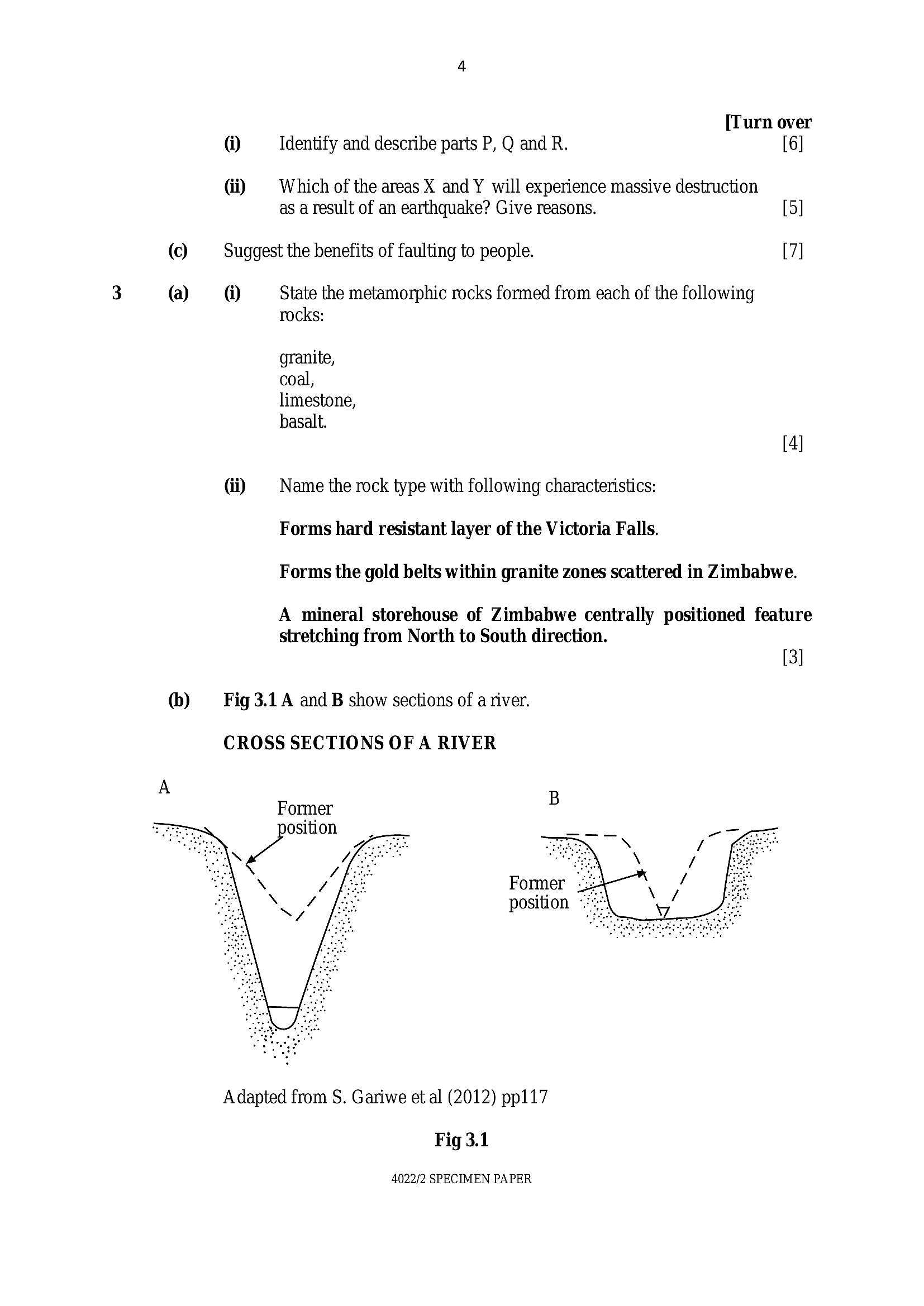
Fig 3.1 A and B show sections of a river.
CROSS SECTIONS OF A RIVER
Former
ae
Adapted from S. Gariwe et al (2012) pp117
Fig 3.1
4022/2 SPECIMEN PAPER
---
Page 5
Extracted Text
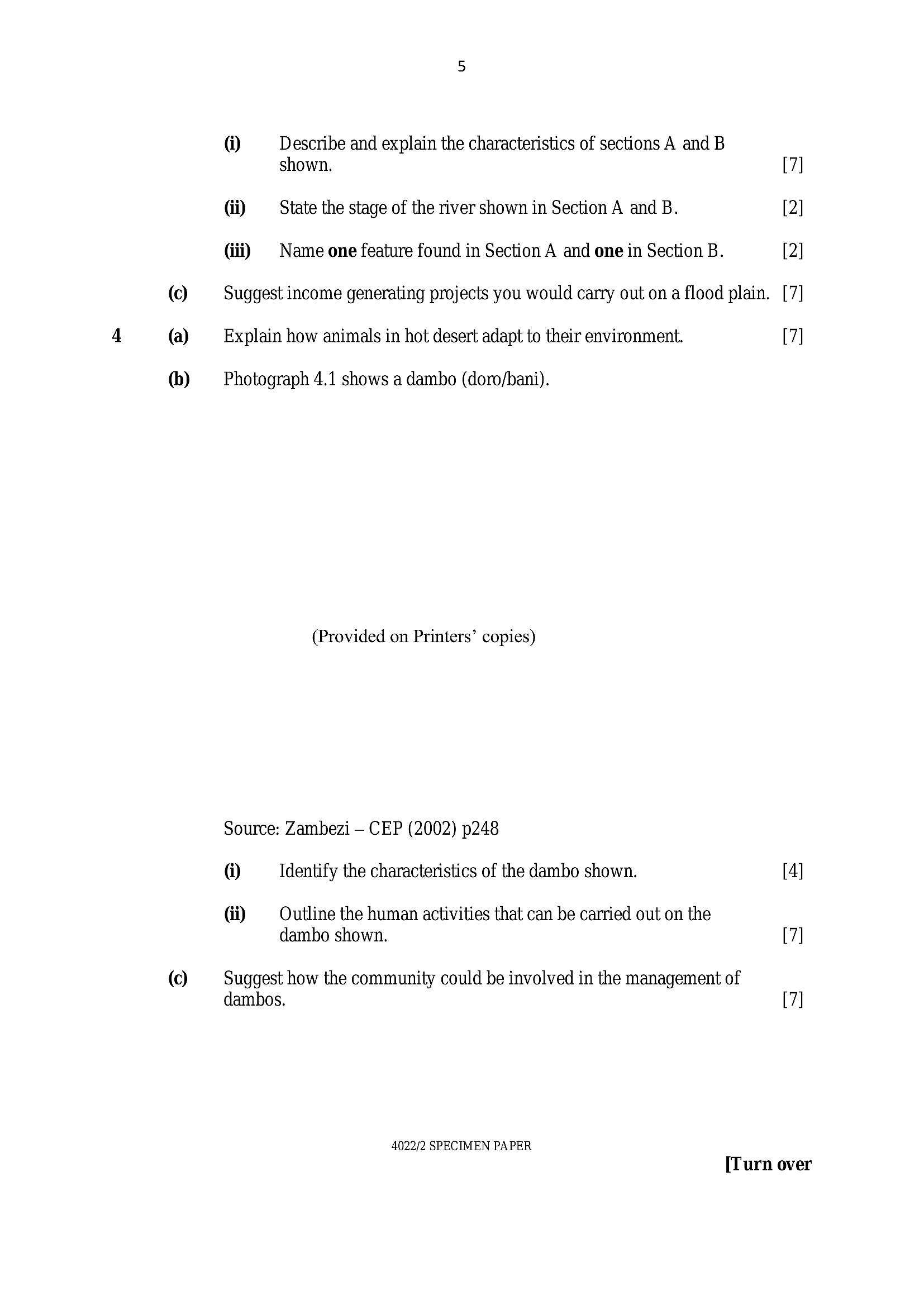
@ Describe and explain the characteristics of sections A and Bshown. 7
di State the stage of the river shown in Section A and B. 2
(iii) | Name one feature found in Section A and one in Section B. 2
(©) Suggest income generating projects you would carry out on a flood plain. [7
(a) Explain how animals in hot desert adapt to their environment. 7
(b) Photograph 4.1 shows a dambo (doro/bani).
(Provided on Printers’ copies)
Source: Zambezi — CEP (2002) p248
@ Identify the characteristics of the dambo shown. [4]
di Outline the human activities that can be carried out on the
dambo shown. [7]
(©) Suggest how the community could be involved in the management of
dambos. [7]
4022/2 SPECIMEN PAPER
[Turn over
---
Page 6
Extracted Text
(a)(b)
(a)
(b)
Section B
Economic G eography
Answer at least one question from this section.
Outline the social and environmental impacts of droughts in Zimbabwe.
[7]
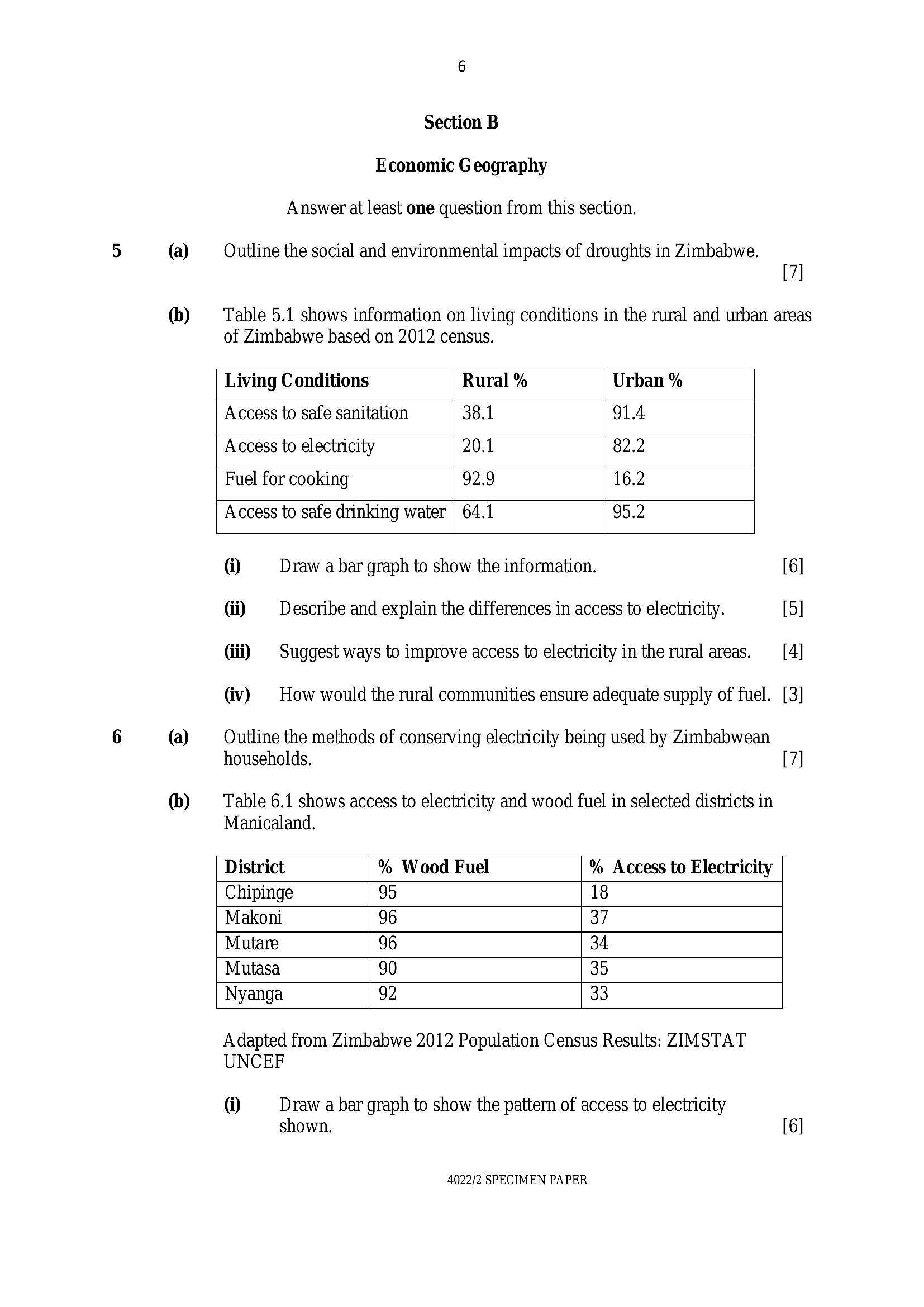
Table 5.1 shows information on living conditions in the rural and urban areas
of Zimbabwe based on 2012 census.
Living Conditions Rural % Urban %
Access to safe sanitation 38.1 91.4
Access to electricity 20.1 82.2
Fuel for cooking 92.9 16.2
Access to safe drinking water | 64.1 95.2
@ Draw a bar graph to show the information. 6]
di Describe and explain the differences in access to electricity. 5]
(iii) | Suggest ways to improve access to electricity in the rural areas. 4]
(iv) | How would the rural communities ensure adequate supply of fuel. [3]
Outline the methods of conserving electricity being used by Zimbabwean
households. 7]
Table 6.1 shows access to electricity and wood fuel in selected districts in
Manicaland.
District % Wood Fuel % Access to Electricity
Chipinge 95 18
Makoni 96 37
Mutare 96 34
Mutasa 90 35
Nyanga 92 33
Adapted from Zimbabwe 2012 Population Census Results: ZIMSTAT
UNCEF
(1) Draw a bar graph to show the pattern of access to electricity
shown. [6]
4022/2 SPECIMEN PAPER
---
Page 7
Extracted Text
(a) 6b)©
di Describe the pattern of access to wood fuel shown. 5
(iii) | Using the state of energy access shown, suggest the measures to
improve access to electricity. 4
(iv) | How is the dependency on wood fuel a threat to the environment. [3
[25
Outline the risks associated with mining. 7
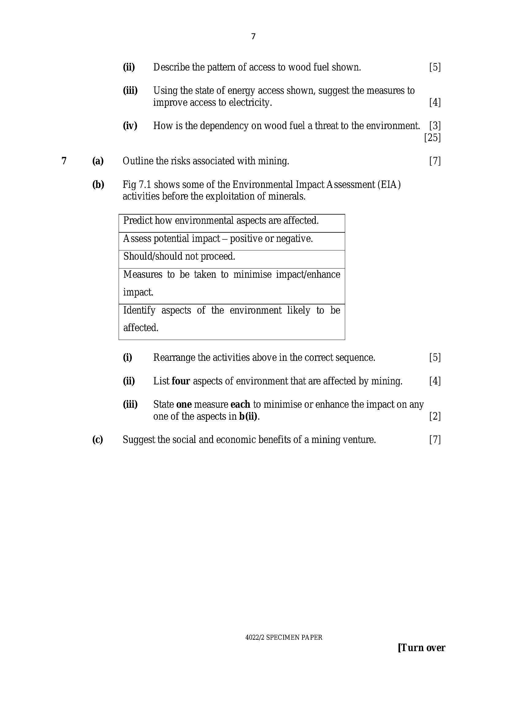
Fig 7.1 shows some of the Environmental Impact Assessment (EIA)
activities before the exploitation of minerals.
Predict how environmental aspects are affected.
Assess potential impact — positive or negative.
Should/should not proceed.
Measures to be taken to minimise impact/enhance
impact.
Identify aspects of the environment likely to be
affected.
@ Rearrange the activities above in the correct sequence. [5]
(ii) List four aspects of environment that are affected by mining. [4]
(iii) State one measure each to minimise or enhance the impact on any
one of the aspects in h(i). [2]
Suggest the social and economic benefits of a mining venture. [7]
4022/2 SPECIMEN PAPER
[Turn over
---
Page 8
Extracted Text
(a) @ List the key provisions of the Environmental Management Act (2002). [4](ii) Name other environmental management legislation in Zimbabwe. [3]
(b) Photograph 8.1 shows degraded environment in Zimbabwe.
(Provided on Printers’ copies)
@ Identity forms of environmental degradation shown. [5]
di Outline the causes of environmental degradation shown. [6]
(©) Plan a project on how you would establish a nature reserve in
your community.
4022/2 SPECIMEN PAPER
---
Page 9
Extracted Text
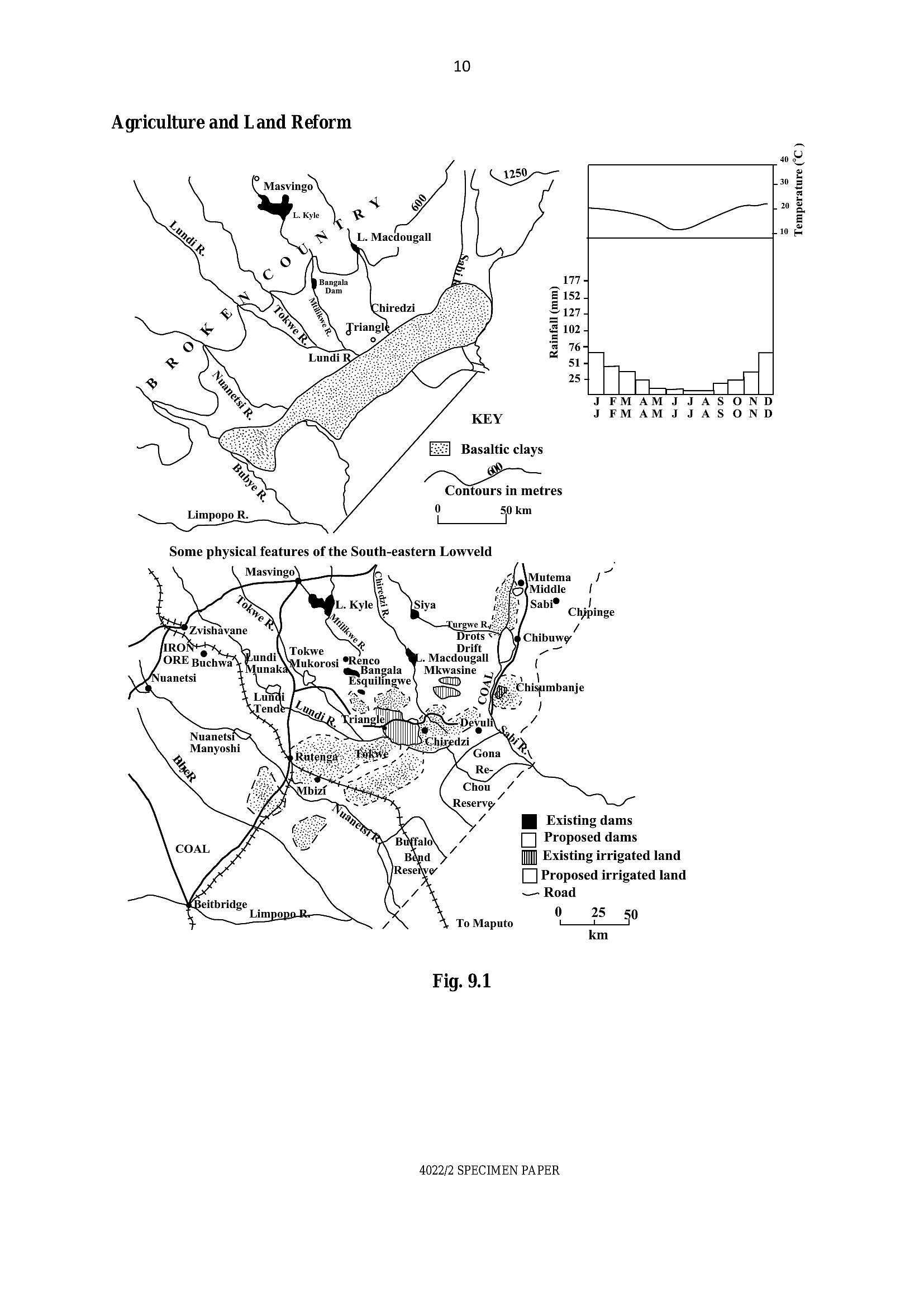
Section C Population, Settlement, Transport and Trade Answer at least one question from this section. (a) Outline the characteristics of market gardening. [7] (b) ‘Fig 9.1 shows the location of a developed commercial farming area.(1) Using information from Fig A, describe and explain the physical
factors that influenced the development of the irrigation projects. [8
(iii) | Name a proposed dam project that has been completed recently
and state two uses of the dam. 3
() @ Suggest the benefits of resettling small scale farmers on the
proposed irrigated land. 4
(iii) | How would you assist the resettled farmers to engage in
commercial production of sugarcane. 3
[25
4022/2 SPECIMEN PAPER
[Turn over
---
Page 10
Extracted Text
10Agriculture and Land Reform
s s
R y
L. Macdougall
20
Temperature (°C )
1774
z 152 4
= 1274
2 1024
=
2 764 _|
S515 LY
“| Thee
—
JFMAMJJASOND
KEY JFMAMJJASOND
Basaltic clays
Contours in metres
0 50 km
LT
Some physical features of the South-eastern Lowveld
C
Mutema /
‘Middle |
© |
Sabi Chipinge
/
Chibuwy
Tokwe “7
. « Renco . Macdougall
Mlukorosi Bangala Mkwasine {
we \
‘hisumbanje
/
7
Nuanetsic>
Manyoshi
%
HB Existing dams
Proposed dams
I Existing irrigated land
Proposed irrigated land
~— Road
0 25
To Maputo Li 90
km
KBeitbridge |
Limpopo R
Fig. 9.1
4022/2 SPECIMEN PAPER
---
Page 11
Extracted Text
1011
11
(a) (1) Give one example of a transnational corporation in Zimbabwe
(TNC). {1
(iv) State the advantages and disadvantages of transnational
corporations in a country. [6
(b) — Using any two examples, draw a diagram showing linkages between
the four types of industry. [11
(©) How would you solve challenges faced by small to medium scale
industries in Zimbabwe. [7
(a) (1) Name two pests and the diseases they cause to people in
Zimbabwe. [4
(ii) Outline the benefits of a healthy population in a country. [3
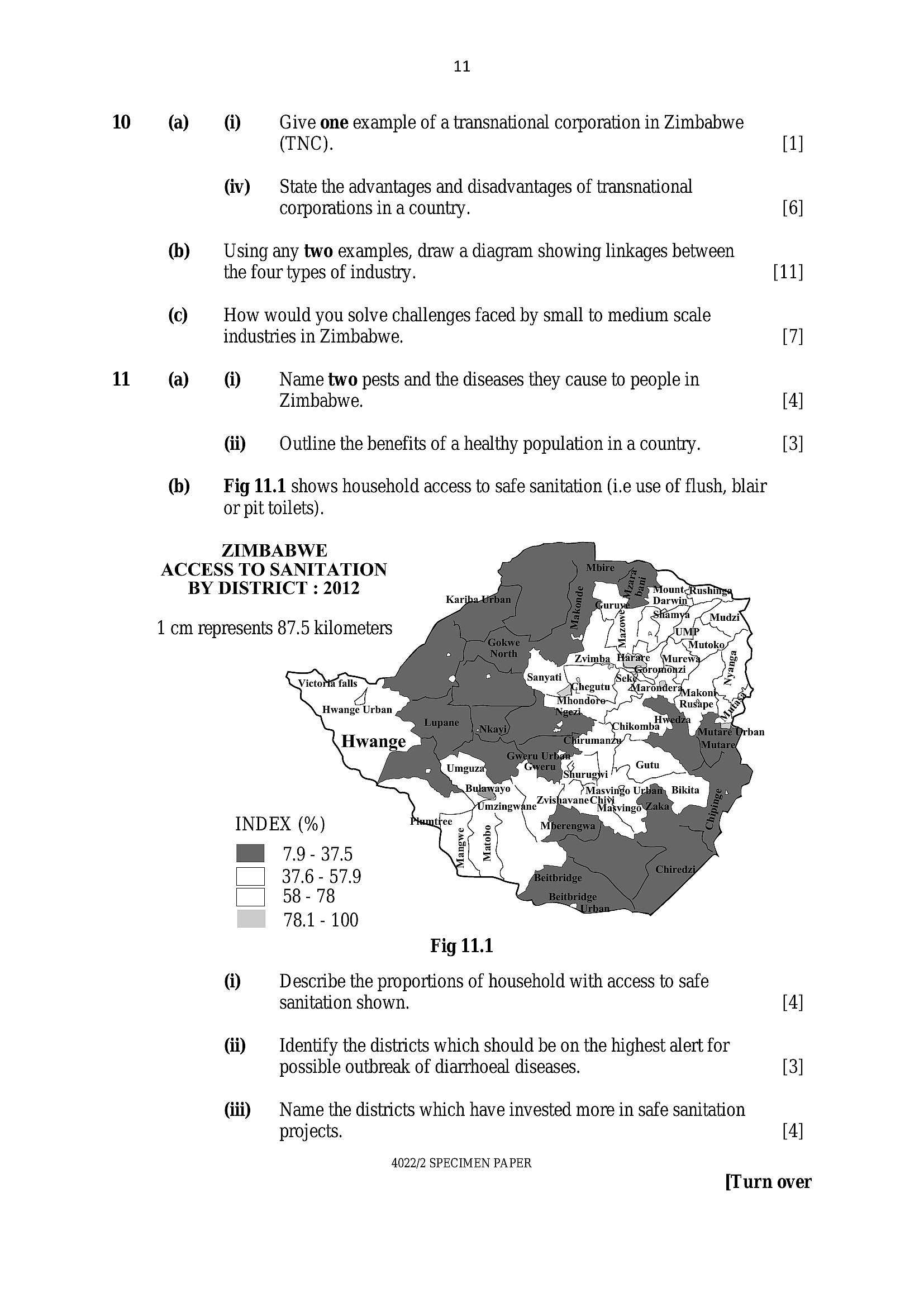
(b) Fig 11.1 shows household access to safe sanitation (i.e use of flush, blair
or pit toilets).
ZIMBABWE
ACCESS TO SANITATION
BY DISTRICT : 2012
1 cm represents 87.5 kilometers
‘Masvingo Uri
ZvishavaneChivi
Mal
INDEX (%)
MH 79-375
37.6 - 57.9
58 - 78
78.1 - 100
Fig 11.1
(1) Describe the proportions of household with access to safe
sanitation shown. [4]
(ii) ‘Identify the districts which should be on the highest alert for
possible outbreak of diarrhoeal diseases. [3]
(iii) | Name the districts which have invested more in safe sanitation
projects. [4]
4022/2 SPECIMEN PAPER
[Turn over
---
Page 12
Extracted Text
12 (a)(b)
©
12
[3]
[25]
(1) Propose ways of ensuring safe water delivery to yourcommunity. [4]
(iii) Outline challenges you are likely to face in an effort to
implement the ways proposed in (c)(i) above.
Outline the advantages of
@ animals,
di bicycles as means of transport.
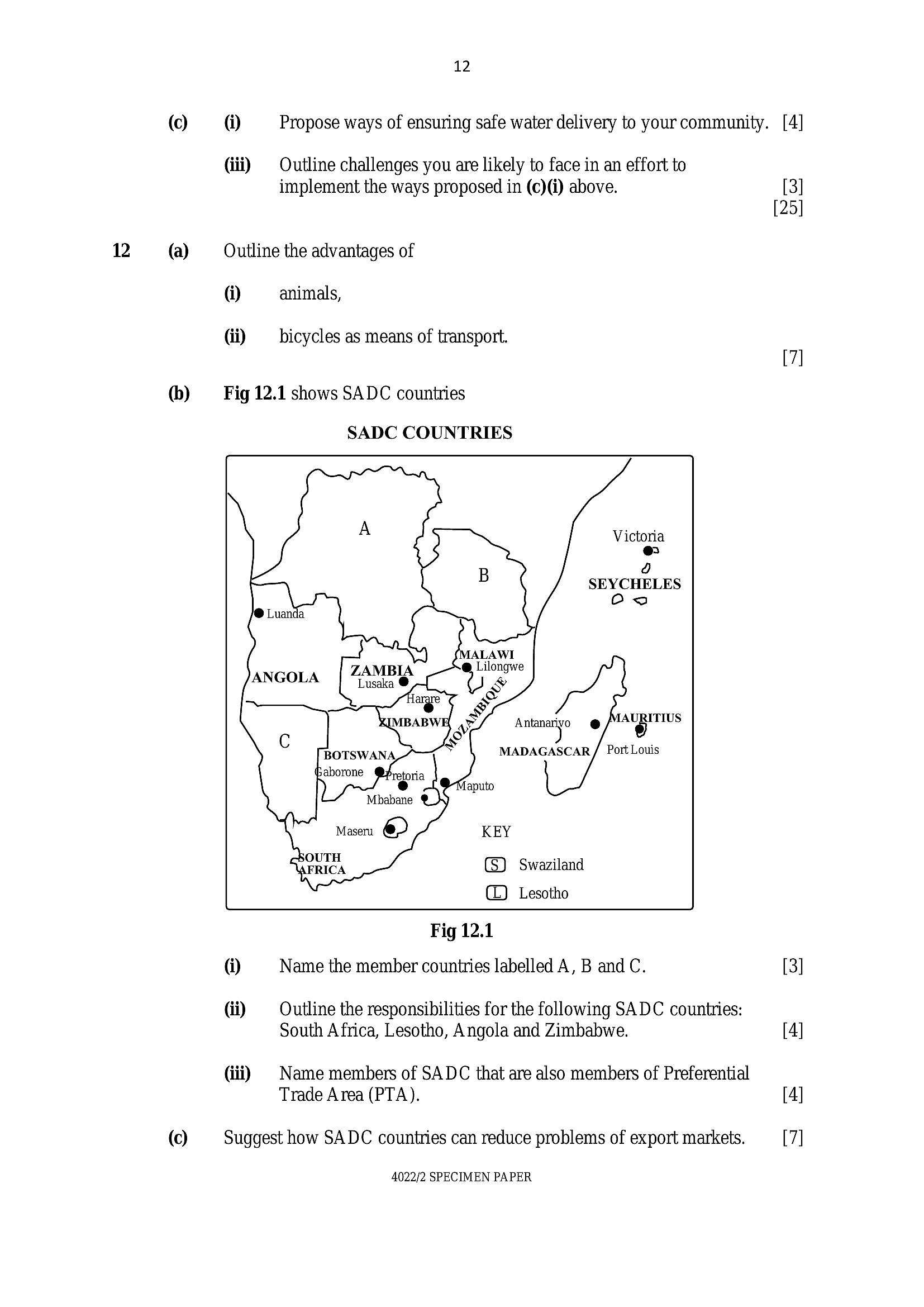
Fig 12.1 shows SADC countries
@
Gi)
(iii)
SADC COUNTRIES
Victoria
r)
a
SEYCHELES
Swaziland
Lesotho
Fig 12.1
Name the member countries labelled A, B and C.
Outline the responsibilities for the following SADC countries:
South Africa, Lesotho, Angola and Zimbabwe.
Name members of SADC that are also members of Preferential
Trade Area (PTA).
Suggest how SADC countries can reduce problems of export markets.
4022/2 SPECIMEN PAPER
---
Struggling with the concepts in this paper?
Revise syllabus notes, key exam points, and interactive practice questions for Physics: