

📄 Exam Questions & Readable Text Transcript
Full OCR-extracted text of questions, syllabus codes, and exam instructions.
Extracted Content: 2017_geo_olevel_mj_paper2
Page 1
Extracted Text
ZIMBABWE SCHOOL EXAMINATIONS COUNCILGeneral Certificate of Education Ordinary Level
GEOGRAPHY 2248/2
PAPER 2
—— JUNE 2017-SESSION-——-—---2-hours-30-minutes
Additional materials:
Answer paper
TIME 2 hours 30 minutes
INSTRUCTIONS TO CANDIDATES
Write your name, centre number and candid
paper/answer booklet.
Answer four questions.
Answer one question from each of Sections A, B and C and one other question from any section.
Write your answers on the separate answer paper provided,
If you use more than one sheet of paper, fasten the sheets together.
INFORMATION FOR CANDIDATES
The number of marks is given in brackets [ ] at the end of each question or part question.
Sketch maps and diagrams should be drawn whenever they serve to illustrate an answer.
This question payer consists of 14 printed pages and 2 blank pages.
Copyright: Zimbabwe School Examinations Council, J2017
©ZIMSEC 32017 [Turn over
---
Page 2
Extracted Text
(a)(b)
2
Settion A (Physical Environment)
Answer at least one question from this section.
Outline the benefits and problems associated with living in a limestone
region,
(7]
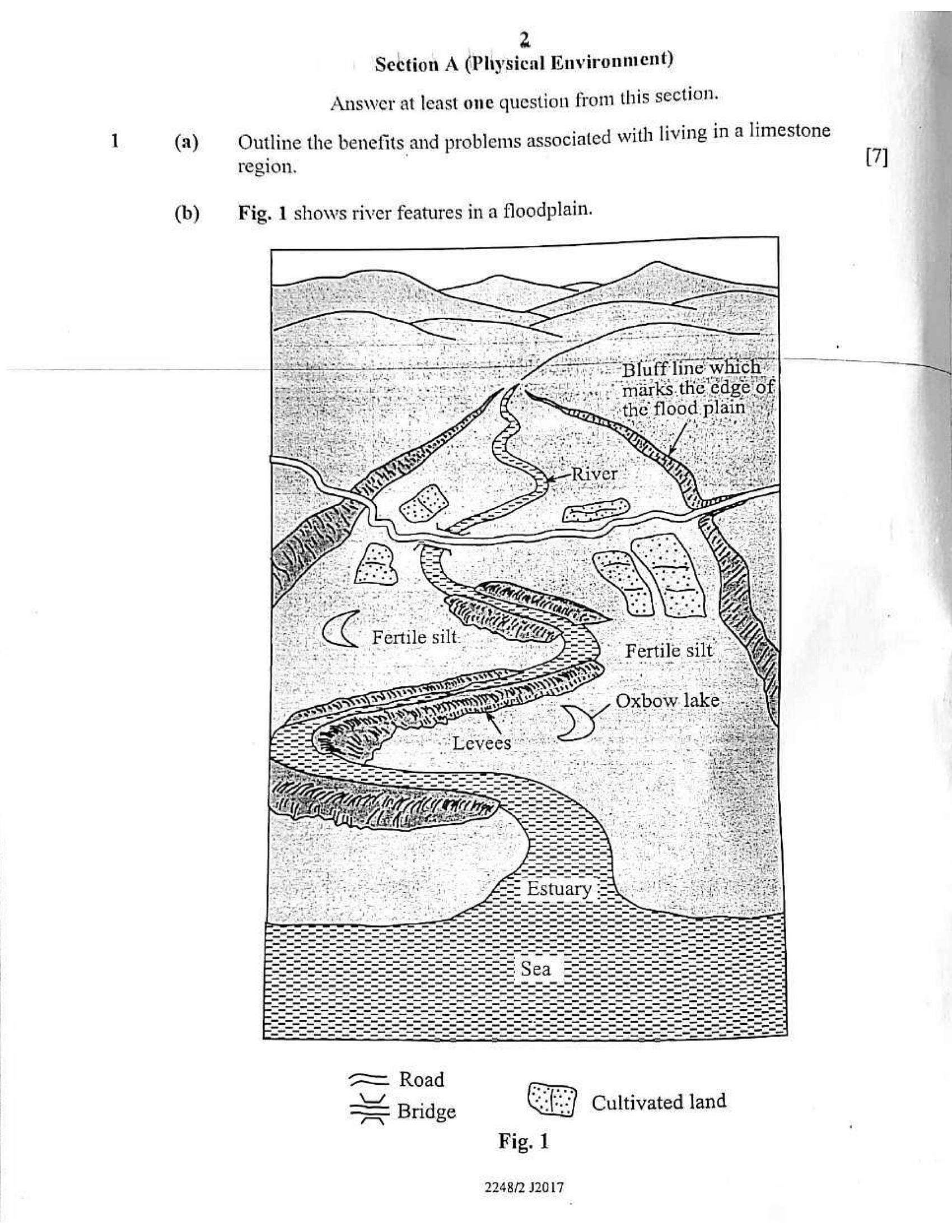
Fig. 1 shows river features in a floodplain.
=— Road
= Bridge Cultivated land
Fig. 1
2248/2 J2017
---
Page 3
Extracted Text
3(i) Using Fig.1, state the possible advantages of settling in the flood
plain shown. [5]
(ii) | With the aid of labelled diagrams, show how levees are formed, (6]
(c) Identify problems posed by fold mountains to people and suggest solutions
to overcome these problems. [7]
(a) (i) Define the term air mass. (2]
(ii) Describe weather associated with a warm front, (4]
~~~ (iti) —Name-the-instrument used-to measure-atmospheric- pressure:- {4—
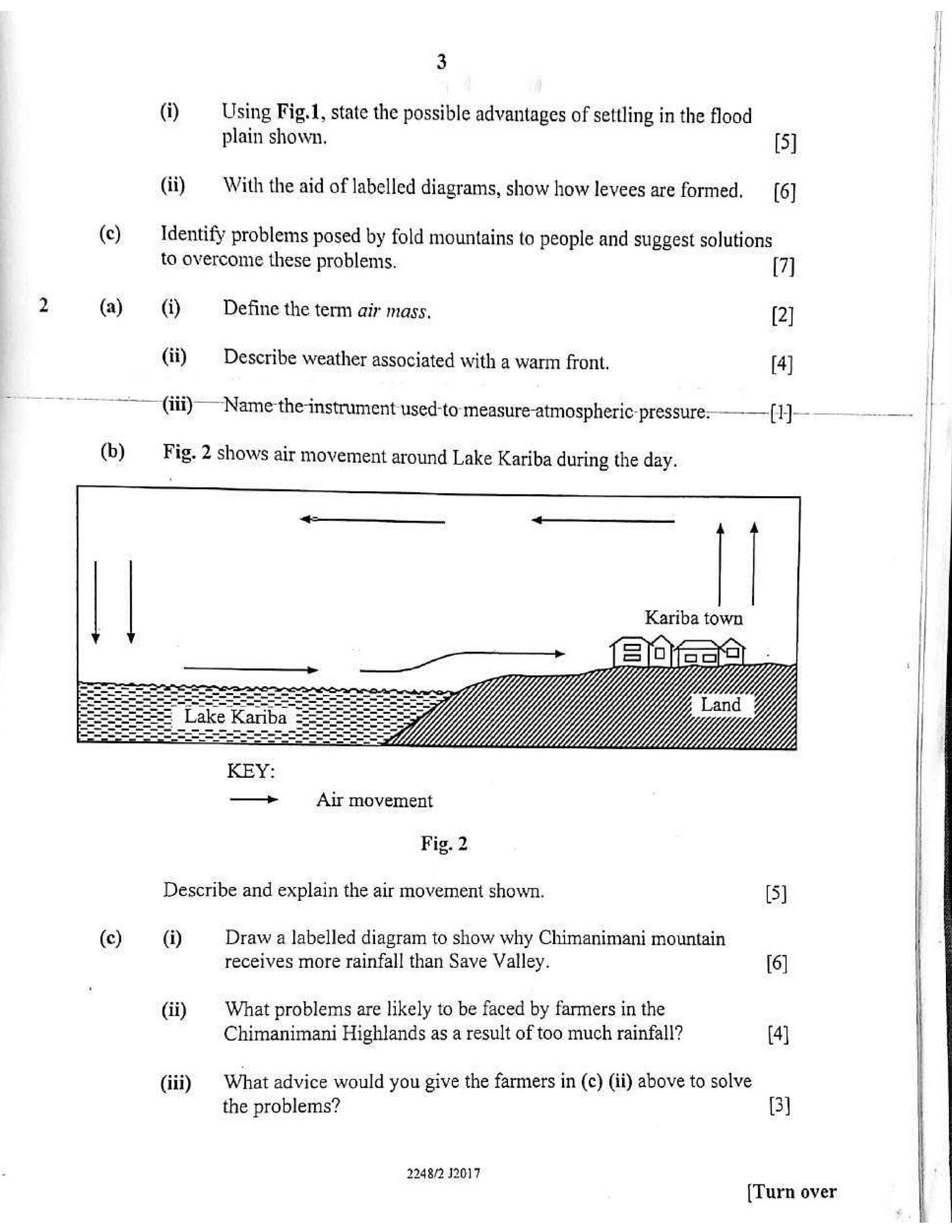
(b) Fig. 2 shows air movement around Lake Kariba during the day.
Kariba town
Air movement
Fig. 2
Describe and explain the air movement shown. [5]
(c) (i) Draw a labelled diagram to show why Chimanimani mountain
receives more rainfall than Save Valley. [6]
(ii) | What problems are likely to be faced by farmers in the
Chimanimani Highlands as a result of too much rainfall? [4]
(iii) What advice would you give the farmers in (c) (ii) above to solve
the problems? (3)
2248/2 J2017 (T
urn over
---
Page 4
Extracted Text
(a)(b)
(c)
(i)
(ii)
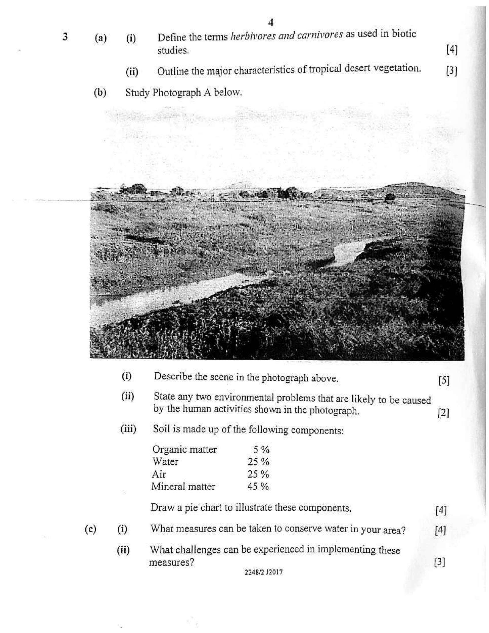
Study Photograph A below.
(i)
(ii)
4
Define the terms /erbivores and carnivores as used in biotic
studies. [4]
Outline the major characteristics of tropical desert vegetation. [3]
Describe the scene in the photograph above. [5]
State any two environmental problems that are likely to be caused
by the human activities shown in the photograph. [2]
Soil is made up of the following components:
Organic matter 5%
Water 25%
Air 25%
Mineral matter 45 %
Draw a pie chart to illustrate these components, [4]
What measures can be taken to conserve water in your area? [4]
What challenges can be experienced in implementing these
measures?
2248/2 12017
---
Page 5
Extracted Text
5|
}
Section B (Economic Geography) |
Answer at least one question from this section. |
4 (a) (i)_~——S Whatare fossil fuels? [2]
(ii) What is the negative impact of mining on the environment
in Zimbabwe? {5]
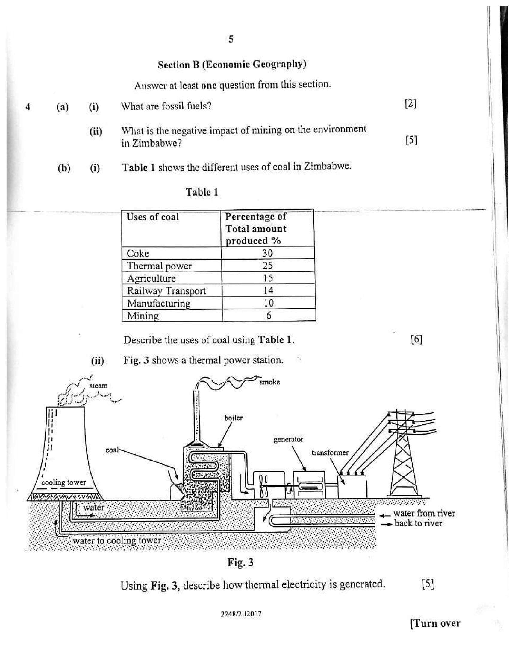
(b) (i) Table 1 shows the different uses of coal in Zimbabwe.
Table 1
“Percentage of —
Total amount
roduced %
Uses of coal
Mining
Describe the uses of coal using Table 1. {6]
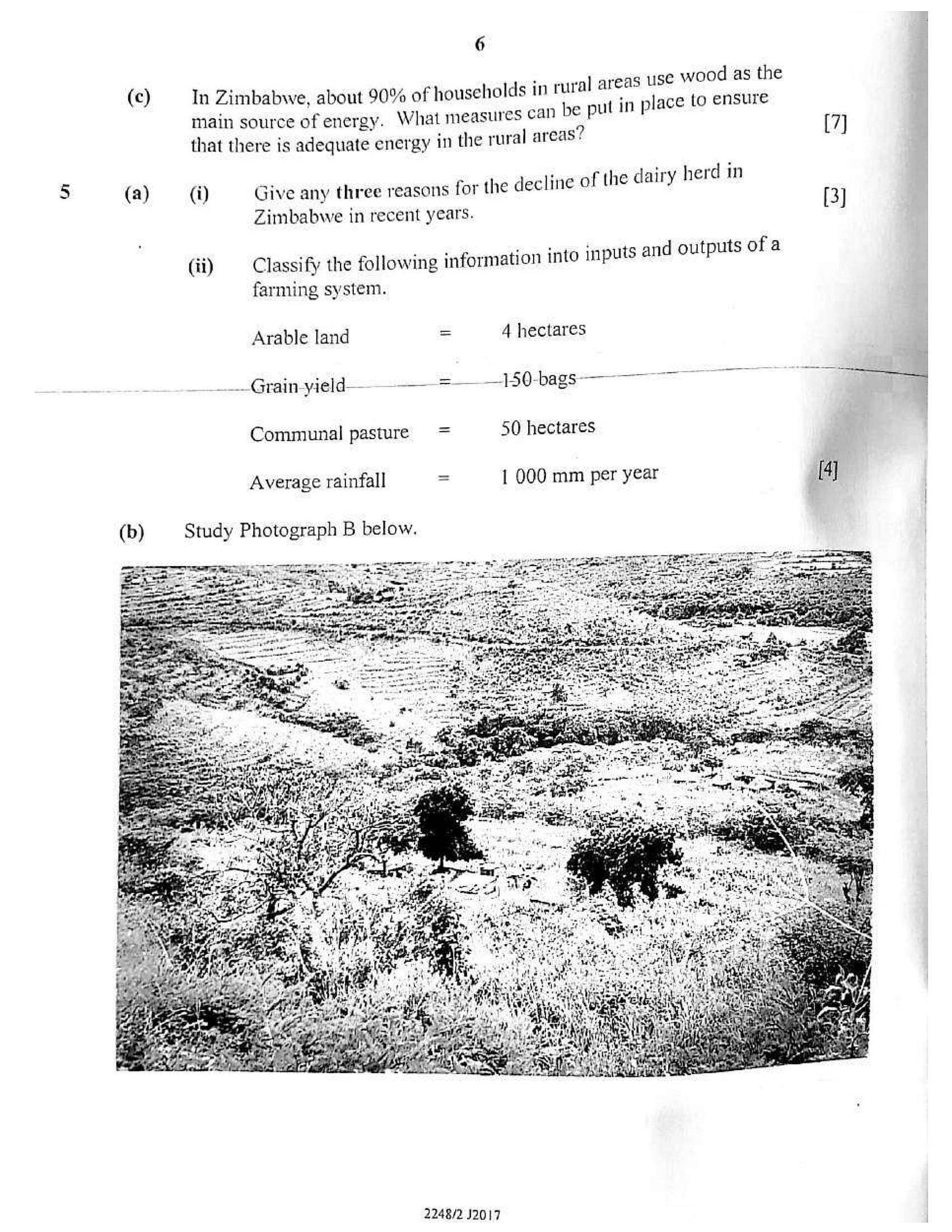
(ii) Fig. 3 shows a thermal power station.
(RH ioe
generator
<— Water from river
—» back to river
Fig. 3
Using Fig. 3, describe how thermal electricity is generated. [5]
2248/2 12017
[Turn over
---
Page 6
Extracted Text
(c)(a)
6
: eal ar vood as the
In Zimbabwe, about 90% of households in rural areas ee 5 SEUNG
main source of energy. What measures can be pul in plac
that there is adequate energy in the rural areas ¢
(i) Give any three reasons for the decline of the dairy herd in
Zimbabwe in recent years.
(ii) Classify the following information into inputs and outputs of a
farming system.
Arable land = 4 hectares
-_Grain-yield— ———-=—_ _150-bags————
Communal pasture = 50 hectares
1 000 mm per year
Average rainfall
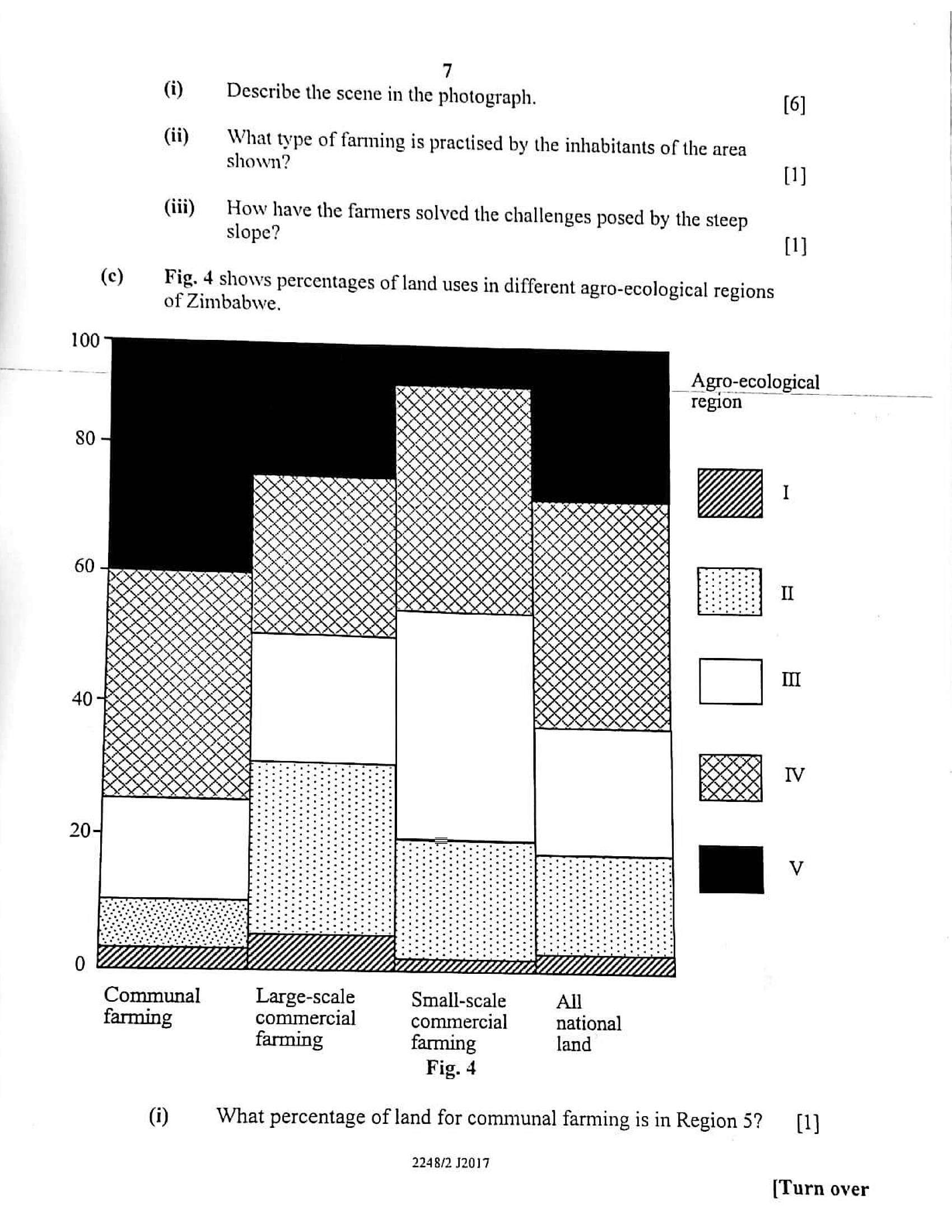
Study Photograph B below.
[7]
[3]
4]
2248/2 J2017
---
Page 7
Extracted Text
7(i) Describe the scene in the photograph. [6]
(ii) What type of farming is practised by the inhabitants of the area
shown? {1}
(iii) | How have the farmers solved the challenges posed by the steep
slope? {1]
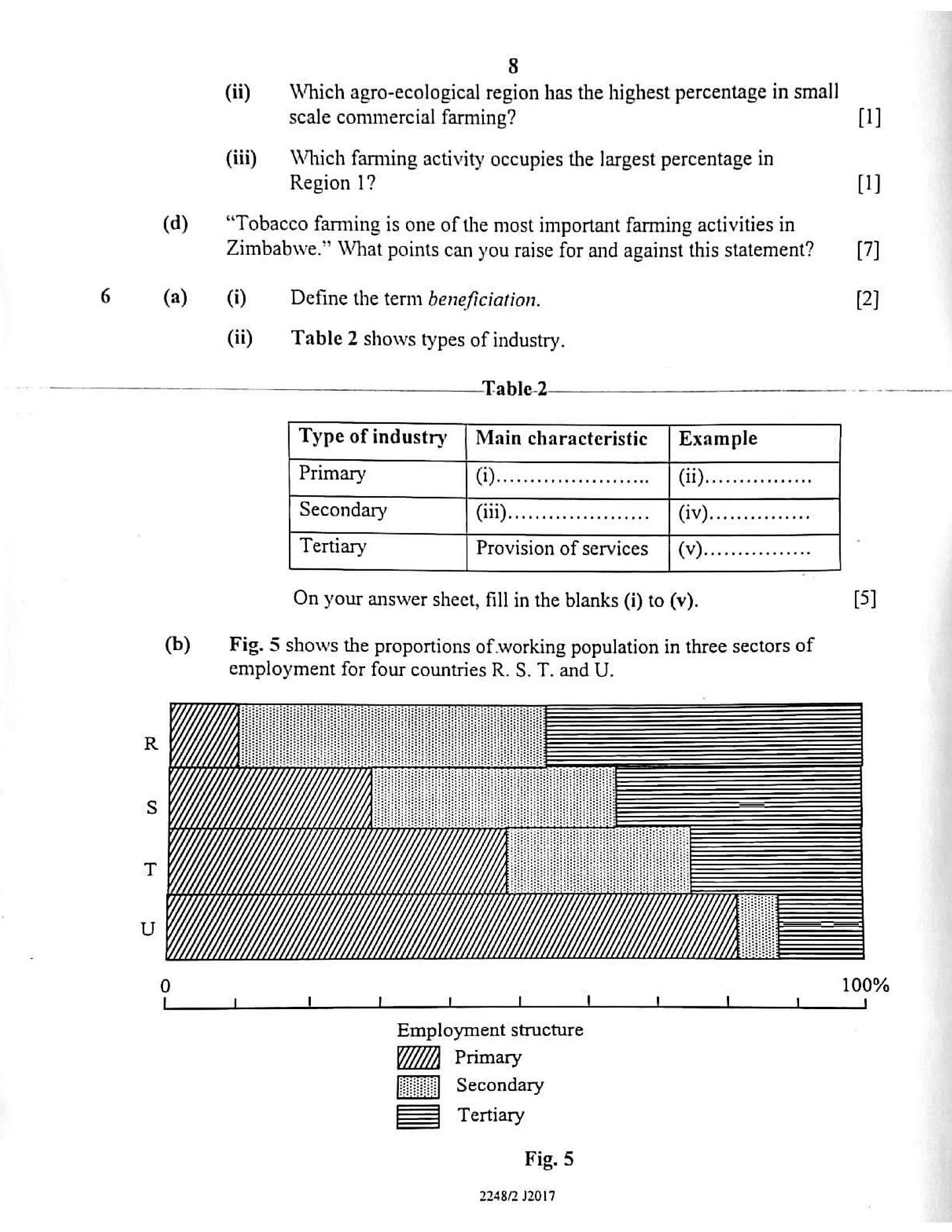
(c) Fig. 4 shows percentages of land uses in different agro-ecological regions
of Zimbabwe.
100
__Agro-ecological
region
ORY
XxX
SS
etasetateconatetats
eeesesecegecereneces
SSS
esecegececereracaces
Seghe
Communal Large-scale Small-scale All
farming commercial commercial national
farming farming land
Fig. 4
(i) What percentage of land for communal farming is in Region 5? {1
2248/2 J2017
[Turn over
---
Page 8
Extracted Text
(d)(a)
8
(ii) | Which agro-ecological region has the highest percentage in smal]
scale commercial farming? {1]
(iii) | Which farming activity occupies the largest percentage in
Region 1? (1)
“Tobacco farming is one of the most important farming activities in
Zimbabwe.” What points can you raise for and against this statement? [7]
(i) Define the term beneficiation. [2]
(ii) Table 2 shows types of industry.
Table2 : oe
Type of industry
Primary
Main characteristic
Secondary
On your answer sheet, fill in the blanks (i) to (v). [5]
Fig. 5 shows the proportions of working population in three sectors of
employment for four countries R. S. T. and U.
100%
Employment structure
Primary
fue] Secondary
= Tertiary
Fig. 5
2248/2 J2017
---
Page 9
Extracted Text
9i Whi ies;
(i) Which of the countries is most economically developed? 0
(ii) State the least conomically developed country. Oy
(iii)
What .
percentage of workers is in the tertiary sector in country T? [1]
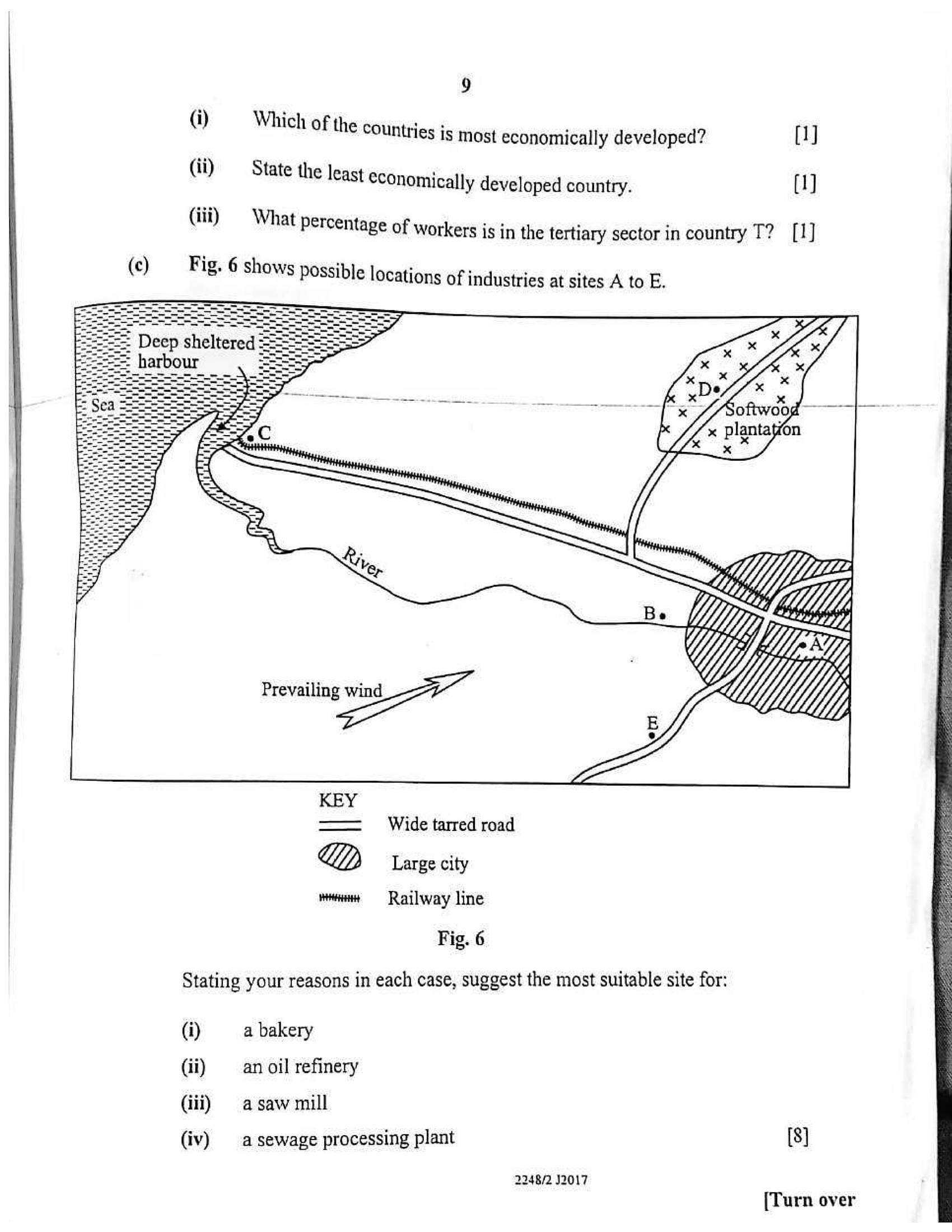
Fig. 6 shows Possible locations of industries at sites A to E.
—— Wide tarred road
My) Large city
wnat == Railway line
Fig. 6
Stating your reasons in each case, suggest the most suitable site for:
(i) a bakery
(ii) —_ an oil refinery
(iii) =asaw mill
(iv) a sewage processing plant [8]
2248/2 J2017
[Turn over
---
Page 10
Extracted Text
(d)10
Zimbabwe has in recent years experienced a decline in industrial output.
(i) What in your view have been the reasons for this decline?
(ii) How could this decline be reduced?
[4]
(3)
294R/2 1217
---
Page 11
Extracted Text
|Sectj :
ection C (Population, Settlement, Transport and Trade)
An i i i
Swer at least one question from this section.
(a) (i) Define the term urbanisation. 2)
(ii) State the main characteristics of the Central Business District
(CBD) ofa city, eI
(iii) — What are the major problems associated with urbanisation? (4)
(iv) How can the problems stated in (a)(iii) above be solved? a
—_(b)__ Draw. a labelled diagram to show the structure of a radial settlement. ree
pattern, a
2248/2 J2017
[Turn over
---
Page 12
Extracted Text
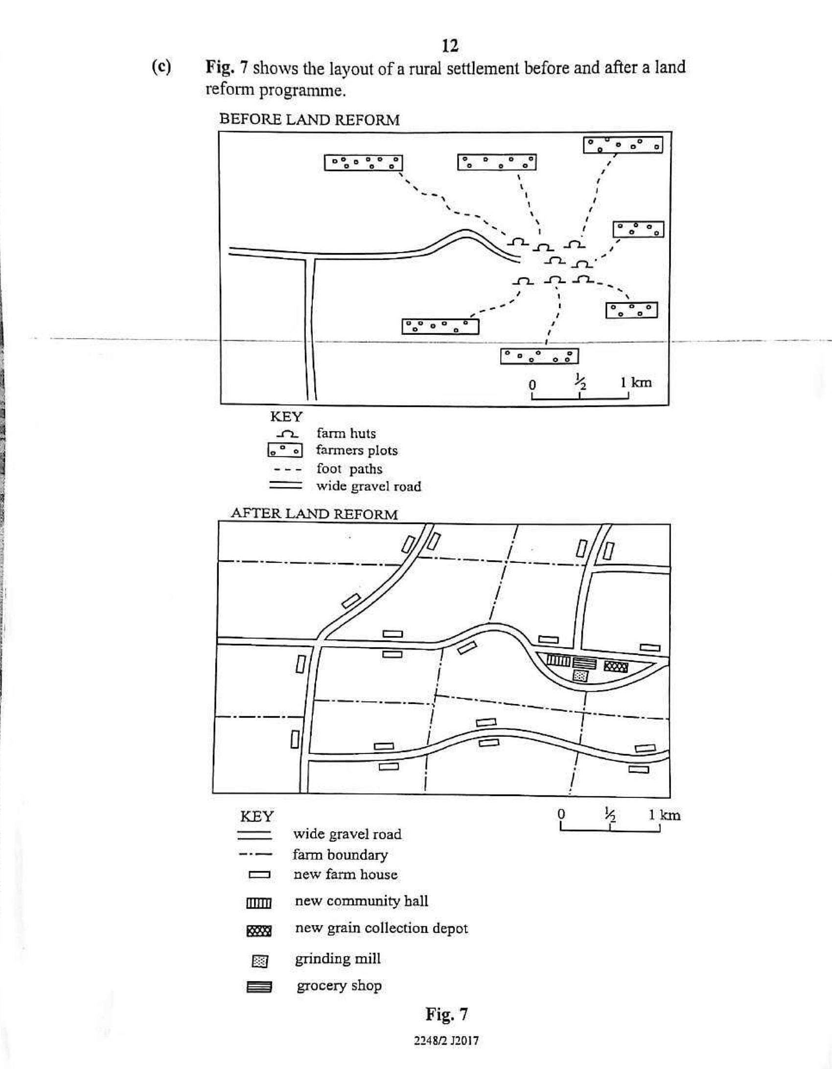
12(c) Fig. 7 shows the layout of a rural settlement before and after a land
reform programme.
BEFORE LAND REFORM
farm huts
farmers plots
- foot paths
— _ wide gravel road
AFTER LAND REFORM
KEY
3
im
at]
wide gravel road
farm boundary
new farm house
new community hall
new grain collection depot
grinding mill
grocery shop
Fig. 7
2248/2 J2017
---
Page 13
Extracted Text
)H DI Gdeiiey Mew were way LldV aK
1 c laKen plac
(i) the land reform. place on the settlement after v
ii) State any two benefits enjoyed by the fi
( changes stated in (c)(i) above. y the farmers as a result of the 2)
(i) Define the terms underpopulation and lati
in population studies. i sail as (4)
(ii) State the factors that are responsible for high birth rates in some
African countries, [2]
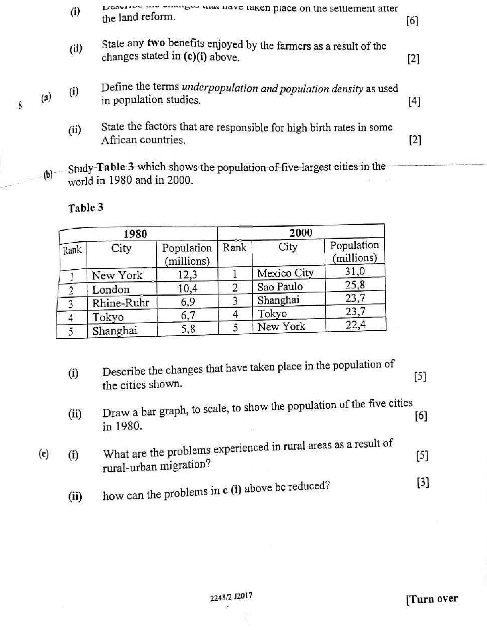
Study Table3 which shows the population of five largest cities in the ——---——-—
world in 1980 and in 2000.
Table 3
| Rank Rank City Population
(millions millions
ri [NewYork | 123 | 1 [MexicoCity | 31.0 |
[2 [tendon | 10,4 | 2 |SaoPaulo | 25,8
3 Rhine-Rubr | 6,9 | 3 [Shanghai | 23.7 __|
4 | 67.14 |Tokyo | 23.7_|
Is [Shanghai | 5,8 | 5 [NewYork | 22,4
—
Les)
BEN
pb
Describe the changes that have taken place in the population of
the cities shown.
(i) I
(ii) | Drawa bar graph, to scale, to show the population of the five cities
in 1980.
(i) | What are the problems experienced in rural areas as a result of
rural-urban migration? [5]
(ii) how can the problems in ¢ (i) above be reduced? (3]
48/2 32017
ane {Turn over
---
Page 14
Extracted Text
14(a) (i) Explain why most rivers in Zimbabwe are not used for water
transport. [3]
(ii) Outline the problems experienced by railway transport in
Zimbabwe. [4]
(iii) | How could the problems stated in a (ii) above be solved? [4]
(b) What are the advantages of using animal drawn carts as a means of
transport in the rural areas of Zimbabwe? [7]
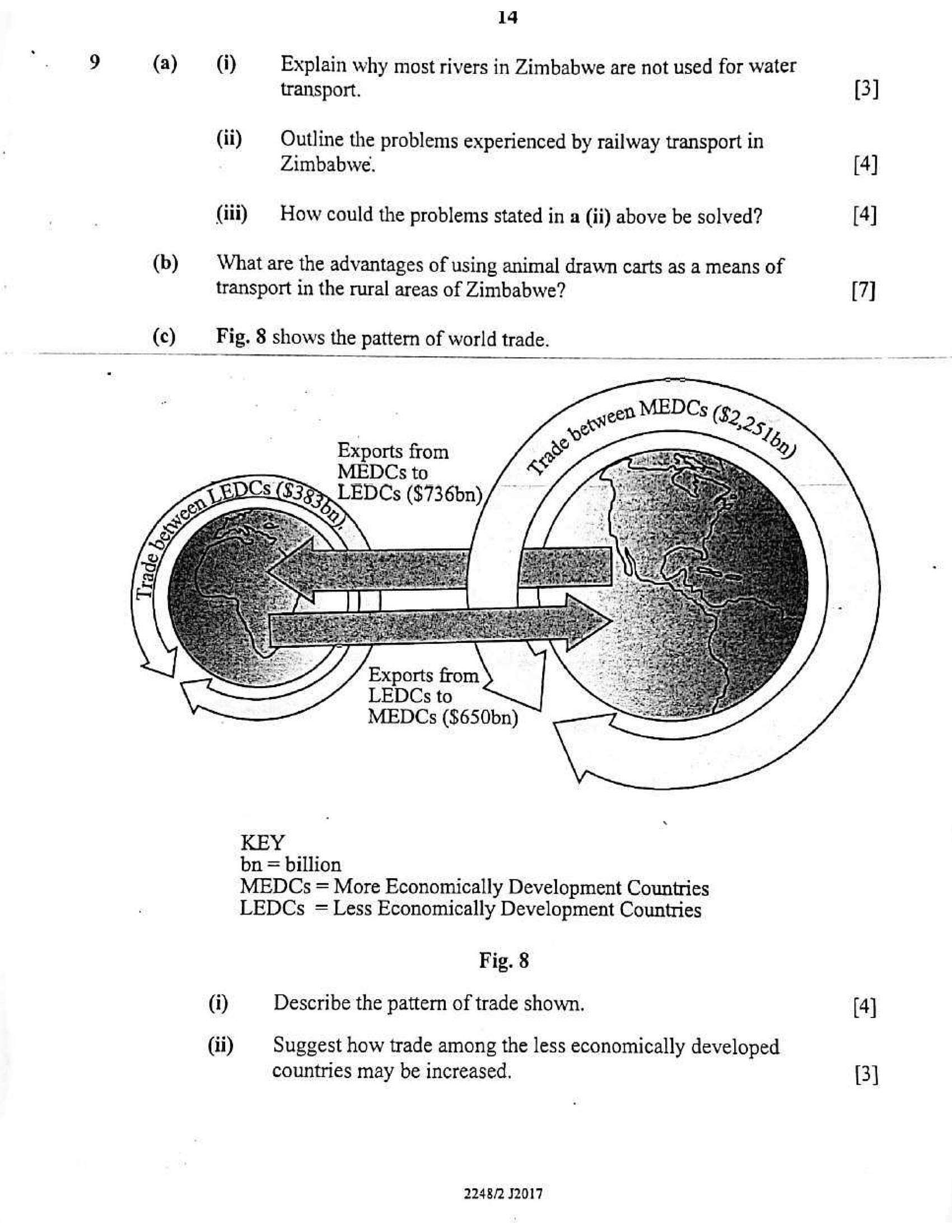
(c) Fig. 8 shows the pattern of world trade.
Exports from
LEDCs to
MEDCs ($650bn)
KEY
bn = billion
MEDCs = More Economically Development Countries
LEDCs = Less Economically Development Countries
Fig. 8
(i) Describe the pattern of trade shown. (4]
(ii) | Suggest how trade among the less economically developed
countries may be increased. (3)
2248/2 J2017
---
Struggling with the concepts in this paper?
Revise syllabus notes, key exam points, and interactive practice questions for Geography: