
📄 Exam Questions & Readable Text Transcript
Full OCR-extracted text of questions, syllabus codes, and exam instructions.
Extracted Content: 2019_geo_olevel_mj_paper2
Page 1
Extracted Text
eae TiTT Bow Performance MetinrrmentZIMBABWE SCHOOL EXAMINATIONS COUNCIL
General Certificate of Education Ordinary Level
GEOGRAPHY 4022/2
PAPER 2
JUNE 2019 SESSION 2 hours 30 minutes
Additional materials:
Answer paper
TIME 2 hours 30 minutes
INSTRUCTIONS TO CANDIDATES
Write your name, centre number and candidate number in the spaces provided on the answer
paper/answer booklet.
Answer four questions. Answer one question from each of sections A, B and C and one other
from any section.
Write your answers on the separate answer paper provided. If you use more than one sheet of
paper, fasten the sheets together.
INFORMATION FOR CANDIDATES
The number of marks is given in brackets [ ] at the end of each question or part question.
Sketch maps and diagrams should be drawn whenever they serve to illustrate an answer.
This question paper consists of 16 printed pages.
Copyright: Zimbabwe School Examinations Council, J2019.
[Turn over
© ZIMSEC J2019
Scanned with CamScanner
---
Page 2
Extracted Text
H a 2 =4oR
OL Ee
Section A (Physical Environment)
Answer at least one question from this section.
a) — With the aid of a diagram describe the internal structure of the earth.
b) Explain the formation of a horst or block mountain.
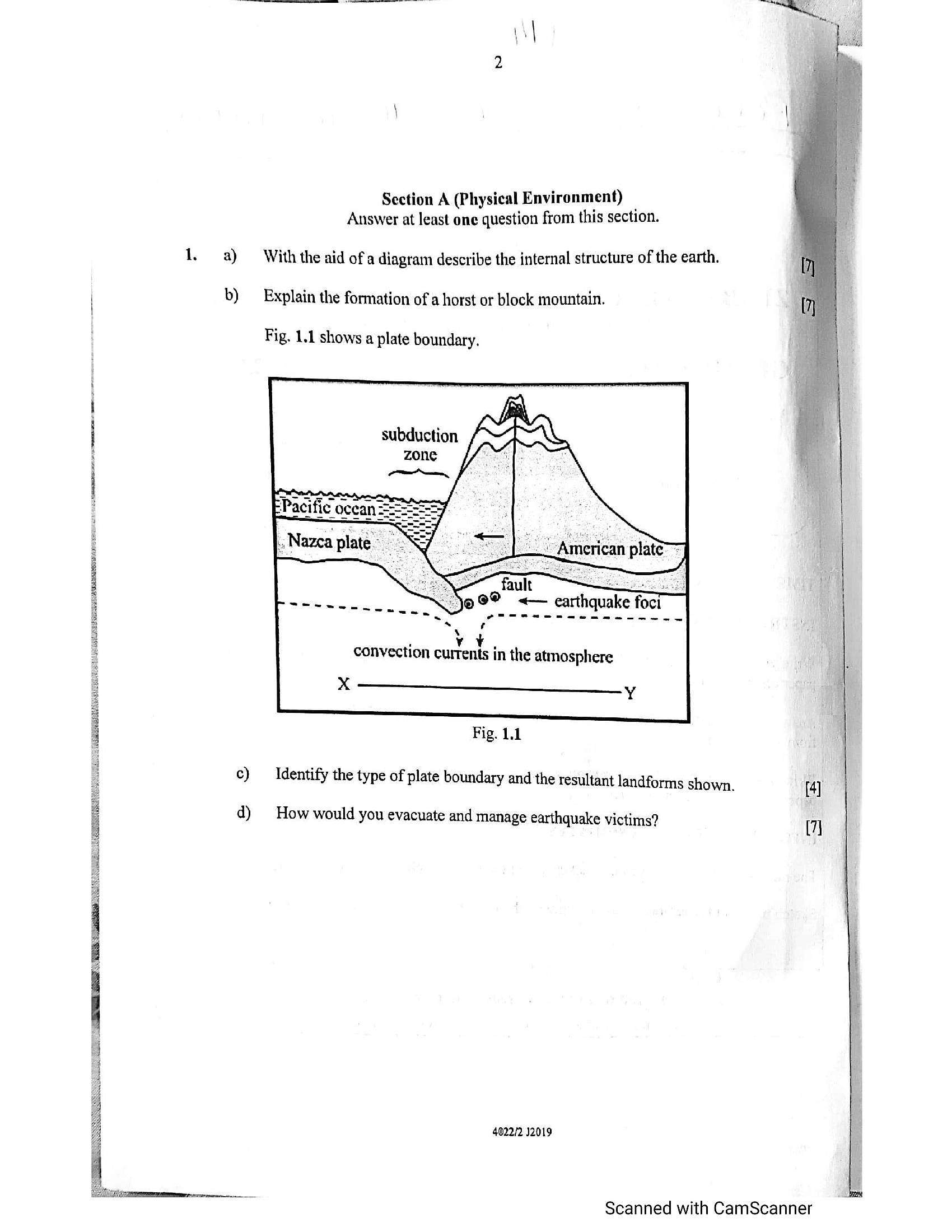
Fig. 1.1 shows a plate boundary.
. vy¥,
convection currents in the atmosphere
xX ———_—<strong></strong>__ yy
Fig. 1.1
c) Identify the type of plate boundary and the resultant landforms shown.
d) How would you evacuate and manage earthquake victims?
4022/2 12019
[4]
7}
Scanned with CamScanner
a”
---
Page 3
Extracted Text
Eee2. a) i) Identify factors that influence the location of a school weather station. [3]
ii) Explain the characteristic of a Stevenson screen. [4]
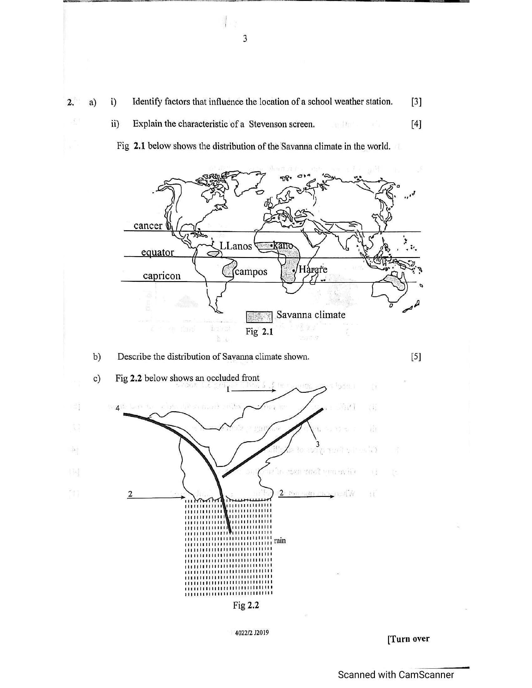
Fig 2.1 below shows the distribution of the Savanna climate in the world.
"| Savanna climate
Fig 2.1
b) Describe the distribution of Savanna climate shown. [5]
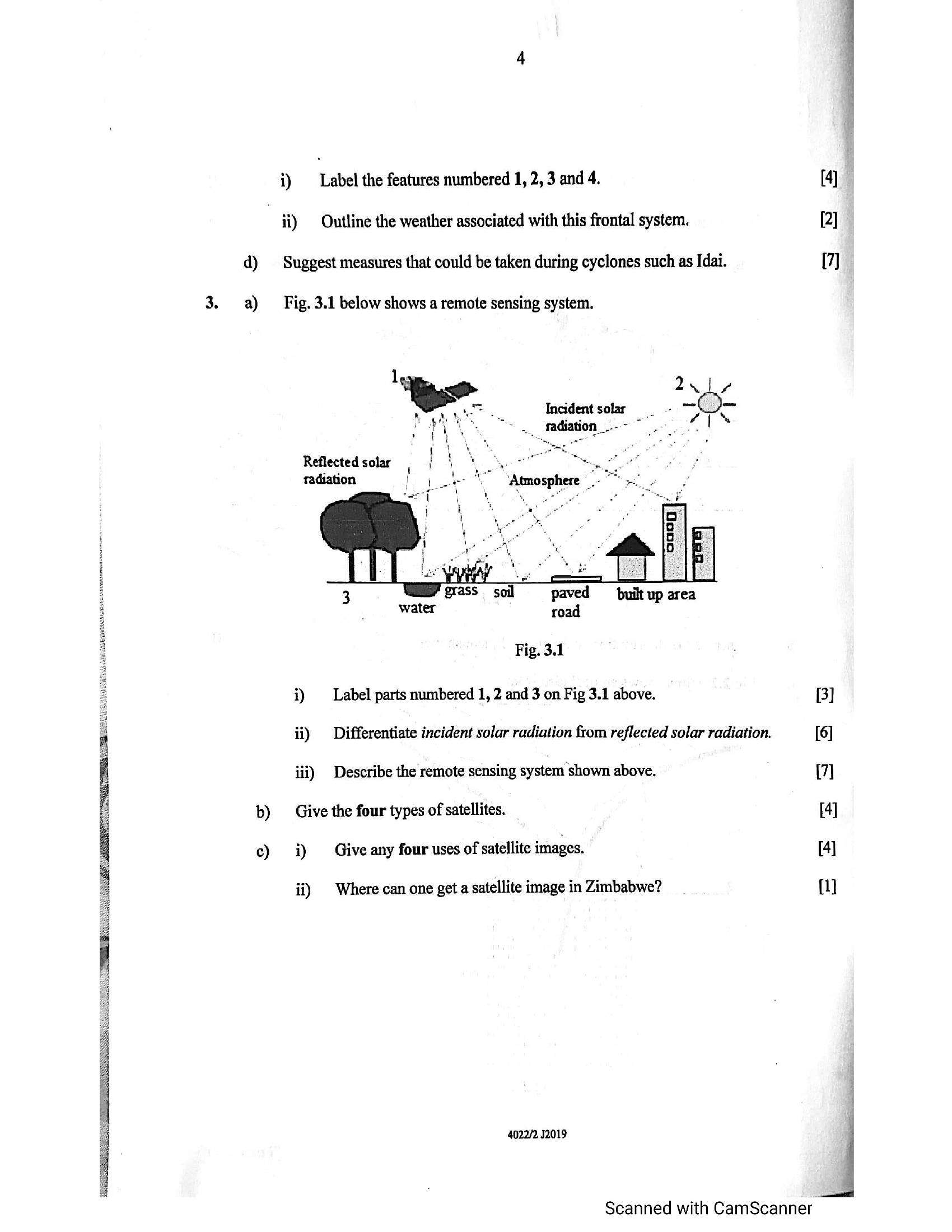
c) Fig 2.2 below shows an occluded front
| —<strong></strong>_>
PeePePeeeeeeese@e renee eared
POP UEEO OP PE TEEPE TEED OE Pt et ae
PeeTeIeeetr are eeeceea tener eee 2aen
POCSEEeEPPDCEUe CUE CUT rete
POCO Pee eeeee ee eeeenet
PIPCEUOUP PEE LeCreeee eee eee
"
Fig 2.2
4022/2 12019
[Turn over
Scanned with CamScanner
---
Page 4
Extracted Text
i) Label the features numbered 1, 2, 3 and 4. [4] . ii) Outline the weather associated with this frontal system. [2] d) Suggest measures that could be taken during cyclones such as Idai. [7]3. a) __ Fig. 3.1 below shows a remote sensing system.
2u1e4
Incident solar woo mm
.., tadiation_.---
i .
Reflected solar, f 4) 4" acne
radiation je Atmosphere |.
water road
i Fig. 3.1
: i) Label parts numbered 1, 2 and 3 on Fig 3.1 above. [3]
; ii) Differentiate incident solar radiation from reflected solar radiation. [6]
iii) Describe the remote sensing system shown above. (7)
b) Give the four types of satellites. [4]
c) i) Give any four uses of satellite images. [4]
ii) | Where can one get a satellite image in Zimbabwe? {]
4022/2 2019
Scanned with CamScanner
---
Page 5
Extracted Text
b)c)
Give any two biotic and two abiotic components of an ecosystem. [4]
Outline the uses of soils to people. (3]
elephant
bacteria
lion
trees
gazele
fungi
TaSS
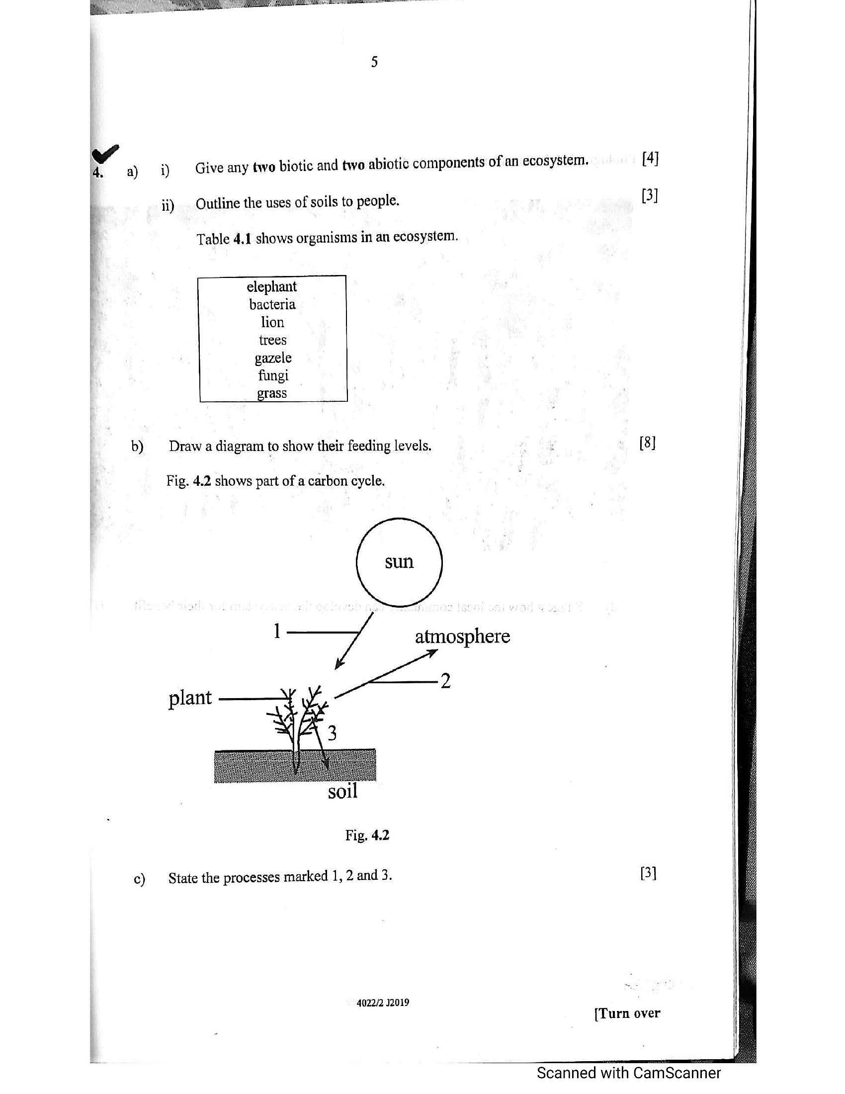
Table 4.1 shows organisms in an ecosystem.
Draw a diagram to show their feeding levels. : [8]
Fig. 4.2 shows part of a carbon cycle.
I atmosphere
2
plant
Fig. 4.2
State the processes marked 1, 2 and 3. 3]
4022/2 12019
{Turn over
Scanned with CamScanner
---
Page 6
Extracted Text
a)b)
¢)
i) _ Give any two biotic and two abiotic components of an ecosystem. [4]
ii) Outline the uses of soils to people. (3]
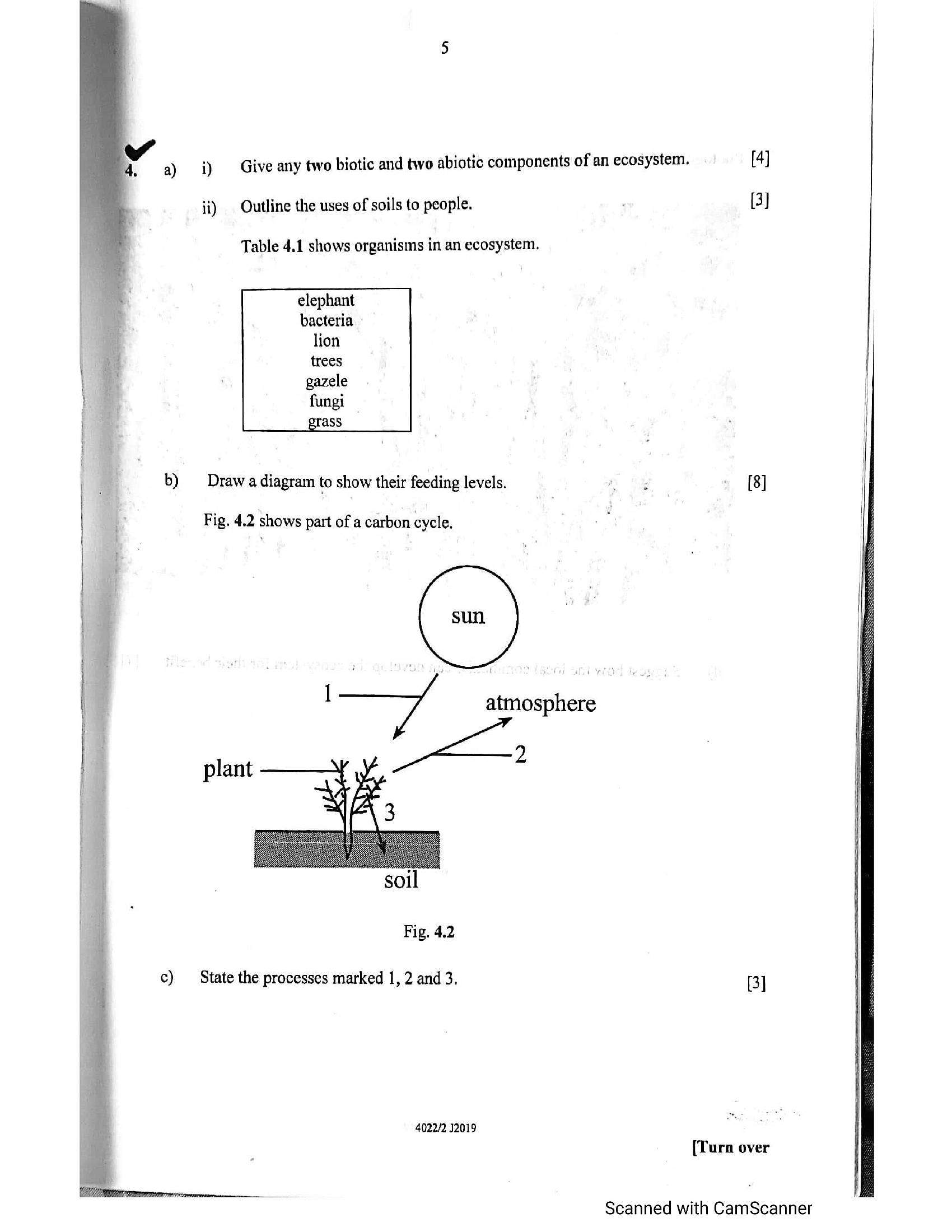
Table 4.1 shows organisms in an ecosystem.
elephant
bacteria
lion
trees
gazele
Draw a diagram to show their feeding levels. cae [8]
Fig. 4.2 shows part of a carbon cycle.
/ atmosphere
2
plant
Fig. 4.2
State the processes marked 1, 2 and 3. BI
4022/2 12019
(Turn over
Scanned with CamScanner
---
Page 7
Extracted Text
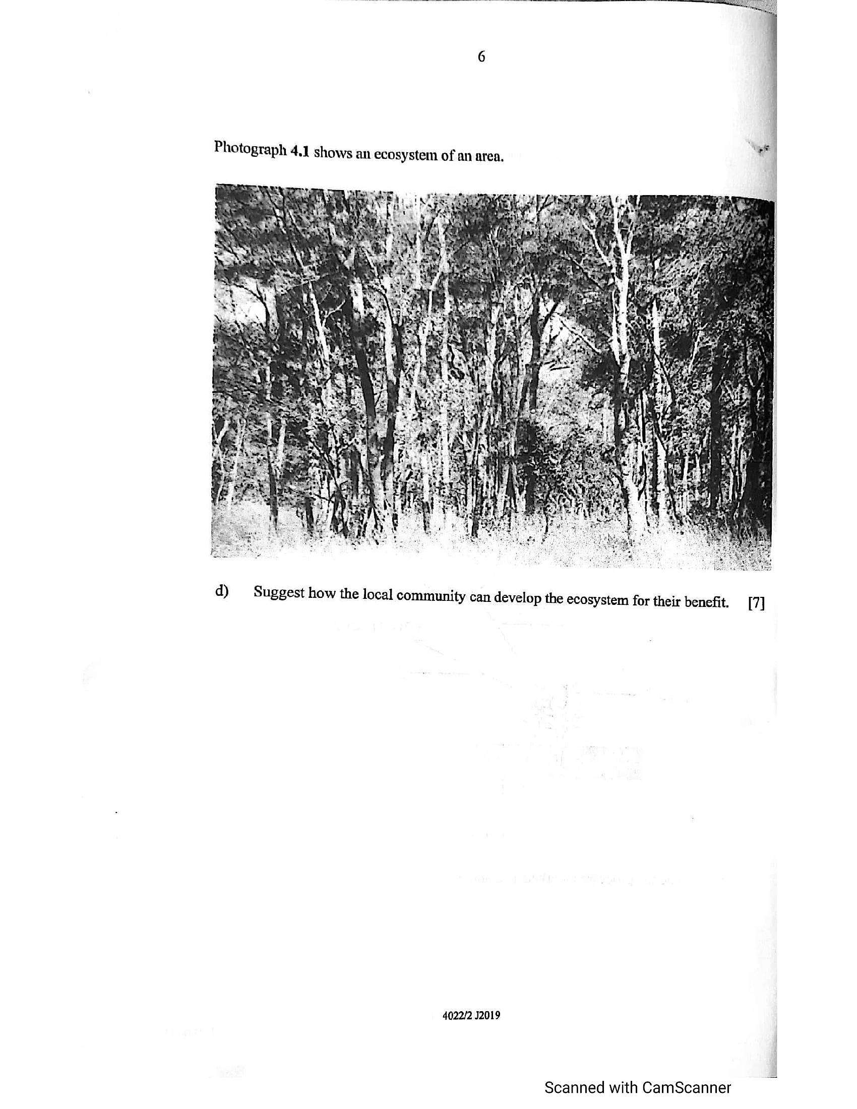
Photograph 4.1 shows an ecosystem of an area,d)
Suggest how the local community can develop the ecosystem for their benefit. [7]
4022/2 J2019
Scanned with CamScanner
---
Page 8
Extracted Text
b)Section B (Economic Geography)
Answer at least one question from this section.
Explain the term Environmental Management. [2]
Outline the methods used to educate the public on environmental issues. [5]
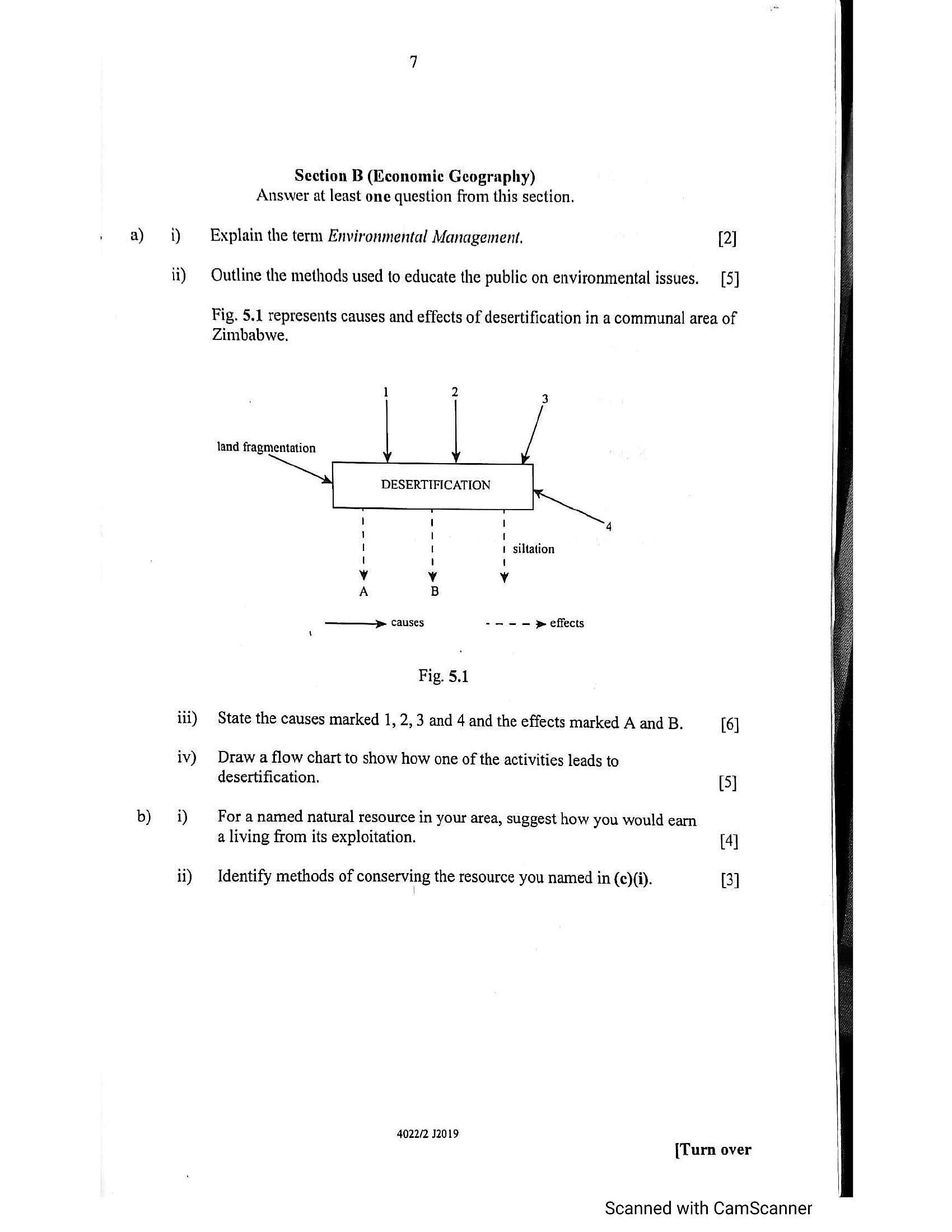
Fig. 5.1 represents causes and effects of desertification in a communal area of
Zimbabwe.
land fragmentation
siltation
! 1 1
1 I 1
! U 1
1 1 '
v Y Vv
A B
——> causes -.-— > effects
Fig. 5.1
State the causes marked 1, 2,3 and 4 and the effects marked A and B. [6]
Draw a flow chart to show how one of the activities leads to
desertification. [5]
For a named natural resource in your area, suggest how you would eam
a living from its exploitation. [4]
Identify methods of conserving the resource you named in (c)(i). [3]
4022/2 32019
[Turn over
Scanned with CamScanner
---
Page 9
Extracted Text
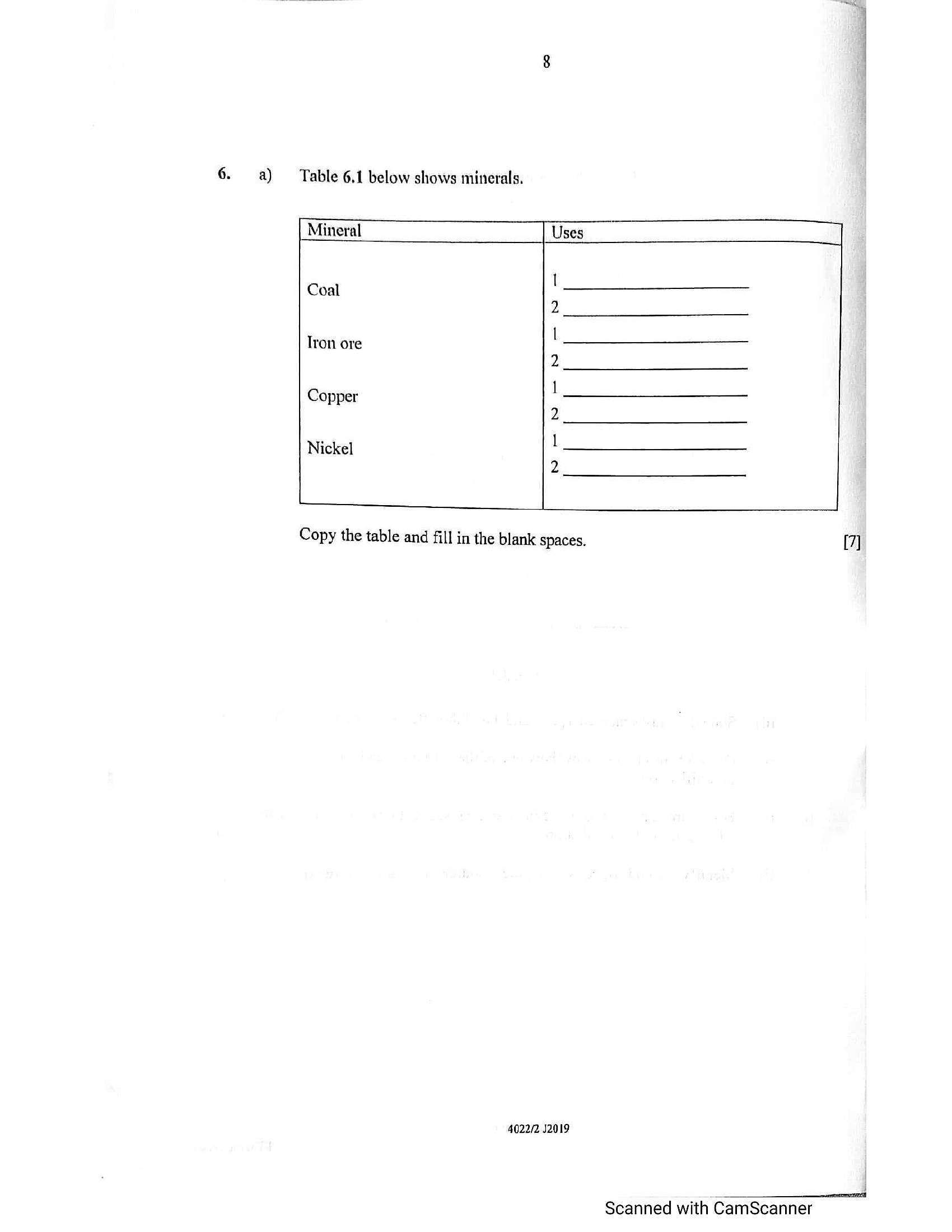
a) Table 6.1 below shows minerals.[ Mineral Uses
Coal
2
Tron ore
2
Copper
2
Nickel
2
L
Copy the table and fill in the blank spaces.
4022/2 J2019
Scanned with CamScanner
[7]
---
Page 10
Extracted Text
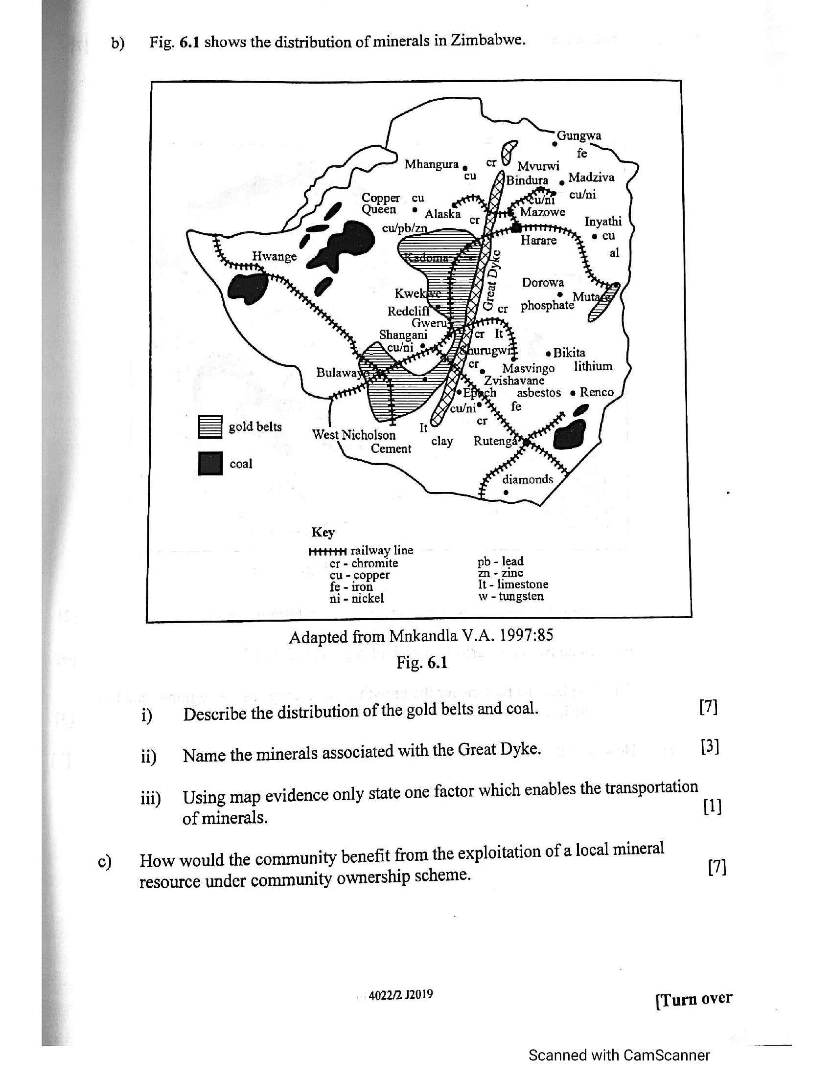
b) Fig. 6.1 shows the distribution of minerals in Zimbabwe.Copper cu
Queen
Masvingo lithium
Zvishavane
asbestos e Renco
diamonds
W .
Key
HtttH railway line
er - chromite pb - lead
cu - copper zm - zinc
fe - iron It - limestone
ni - nickel w - tungsten
Adapted from Mnkandla V.A. 1997:85
Fig. 6.1
i) Describe the distribution of the gold belts and coal. (7)
ii) | Name the minerals associated with the Great Dyke. 13]
Using map evidence only state one factor which enables the transportation
iii)
of minerals. [1]
c) How would the community benefit from the exploitation of a local mineral
resource under community ownership scheme. (7)
4022/2 32019 (Turn over
Scanned with CamScanner
---
Page 11
Extracted Text
7.a) Outline the characteristics of communal farming in Zimbabwe.
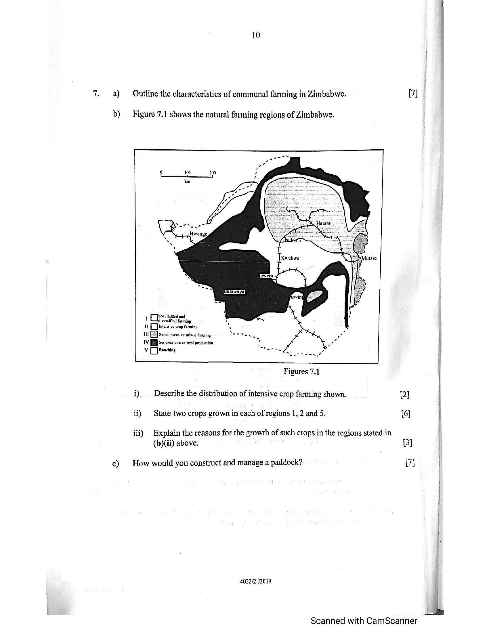
b) Figure 7.1 shows the natural farming regions of Zimbabwe.
Spevialized und
! OR fanning
U1 [[]imensise crop farming
111 [3] scom-intensive mixed farming
IV JB Semi-cxtcnsive beef production
Vv Oo Ranching
Figures 7.1
i) _ Describe the distribution of intensive crop farming shown.
ii) State two crops grown in each of regions 1, 2 and 5,
iii) Explain the reasons for the growth of such crops in the regions stated in
(b)(ii) above. j
¢) How would you construct and manage a paddock?
4022/2 J2019
7]
2
i
Bl
7] |
Scanned with CamScanner
---
Page 12
Extracted Text
8.11
a) Using examples, outline the importance of Small to Medium Enterprises
(SMEs) industries in your area, [7]
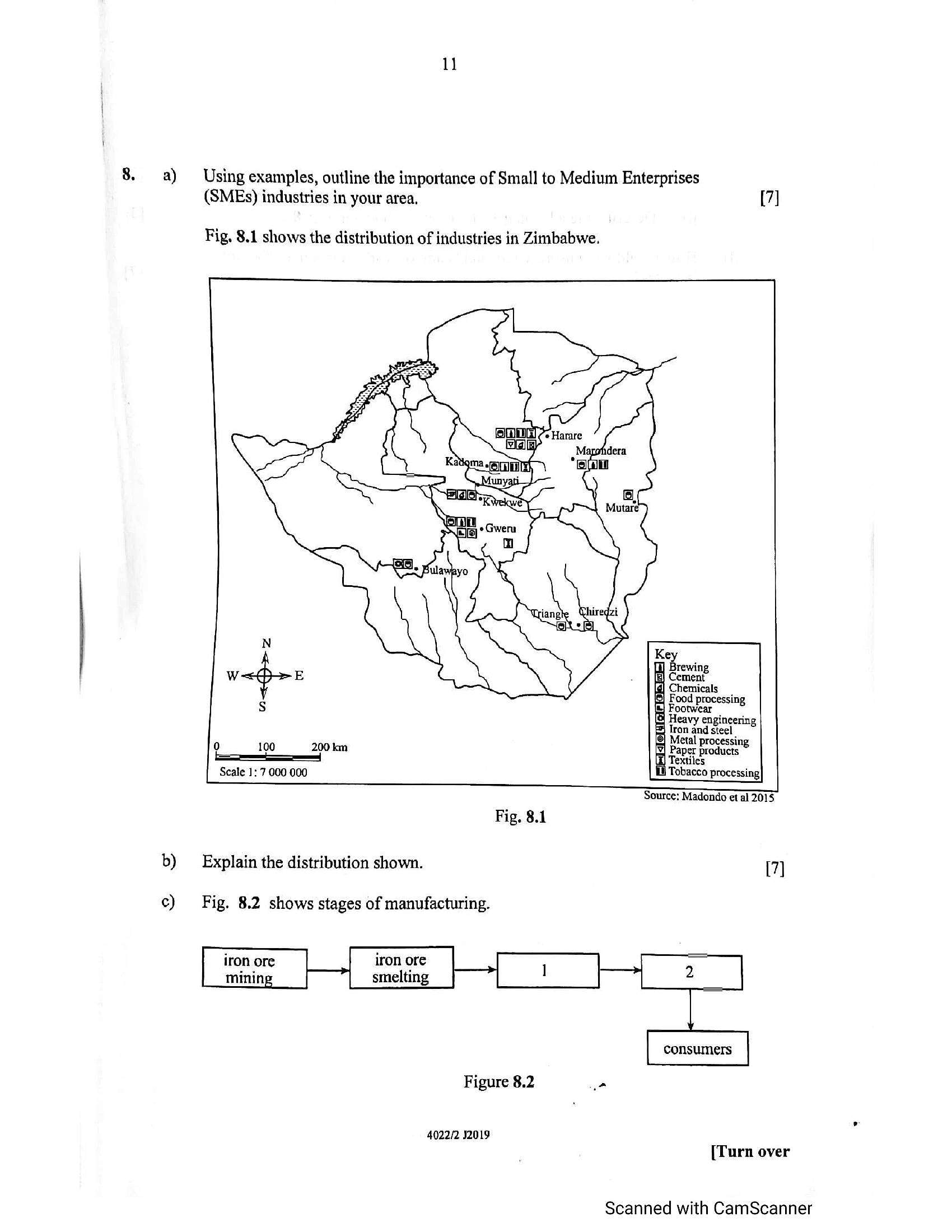
Fig. 8.1 shows the distribution of industries in Zimbabwe.
i Chemicals
Is} Fe food prox processing
| Heavy euinicering
= Iron and steel
{e) Merl Processing
{¥| Paper products
Fa Textiles
1} acco in;
Scale 1: 7 000 000 ol Processing}
Source: Madondo et al 2015
Fig, 8.1
b) Explain the distribution shown. [7]
c) Fig. 8.2 shows stages of manufacturing.
iron ore
mining
Figure 8.2 ”
4022/2 32019
[Turn over
Scanned with CamScanner
---
Page 13
Extracted Text
qd)12
i) Identify stages represented by boxes 1 and 2. 2]
ii) Describe the advantages of the set up shown in Fig 8.2. [2]
How would you ensure safety and health of workers in a manufacturing ta
industry?
4022/2 J2019
Scanned with CamScanner
ne
---
Page 14
Extracted Text
9.Section C (population, Settlement,
Answer at least one qu
Environment, transport and Trade)
estion ftom this section.
Table 9.1 below shows a list of types of power used in Zimbabwe.
Solar
hydroelectricity
thermal power
biogas
a) i) — Classify the types of power in Table 9.1 into renewable and non
renewable.
[4]
ii) Describe how biogas is produced. 2]
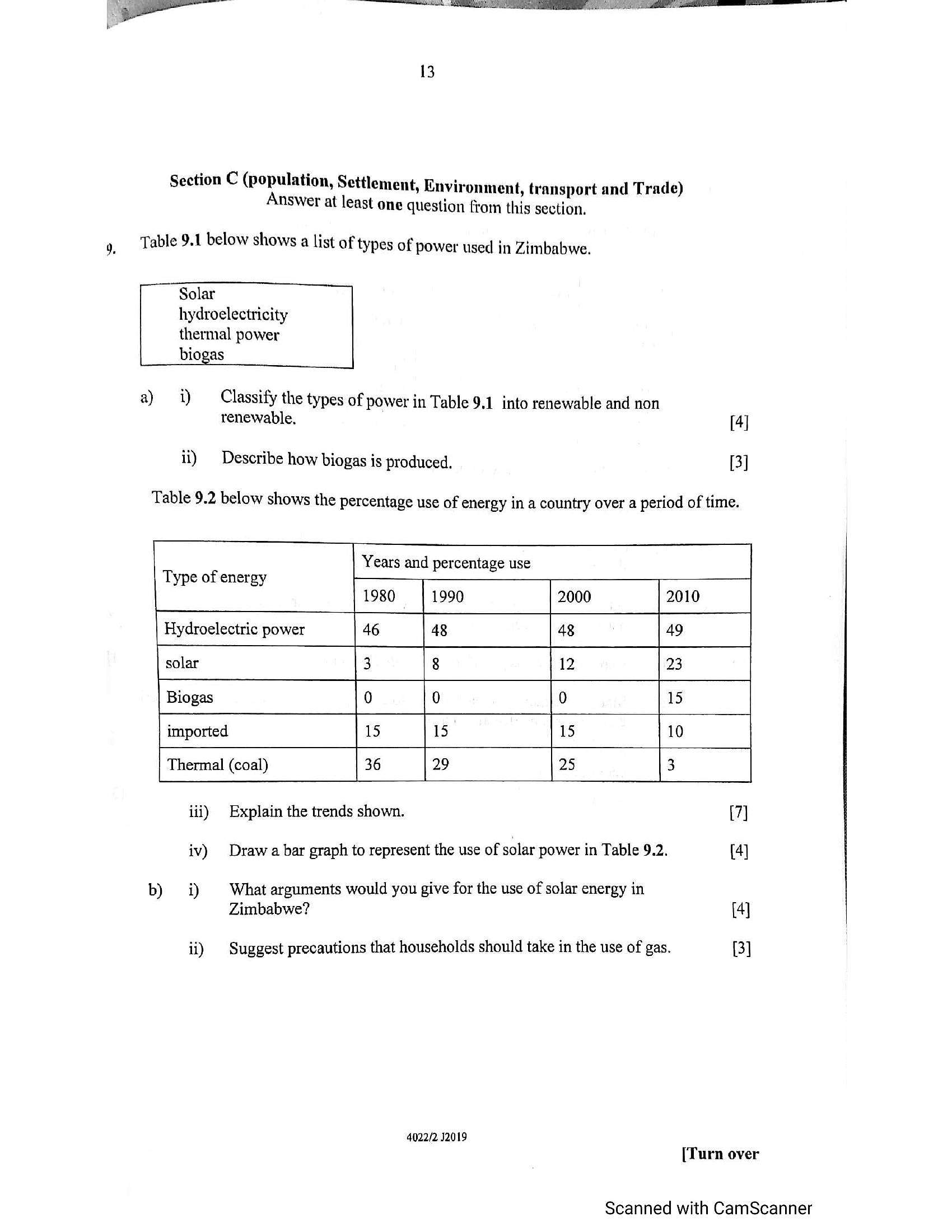
Table 9.2 below shows the percentage use of energy in a country over a period of time.
Years and percentage use ]
Type of energy
1980 1990 2000 2010
| ; ——————
Hydroelectric power 46 48 48 49
solar 3 8 12 23
Biogas 0 0 0 15
imported 15 15 15 10
6 29 25 3
Thermal (coal) 3
iii) Explain the trends shown. (7]
iv) Draw a bar graph to represent the use of solar power in Table 9.2. (4]
b) i) What arguments would you give for the use of solar energy in
Zimbabwe? (4]
ii) | Suggest precautions that households should take in the use of gas. 3]
4022/2 12019
[Turn over
Scanned with CamScanner
---
Page 15
Extracted Text
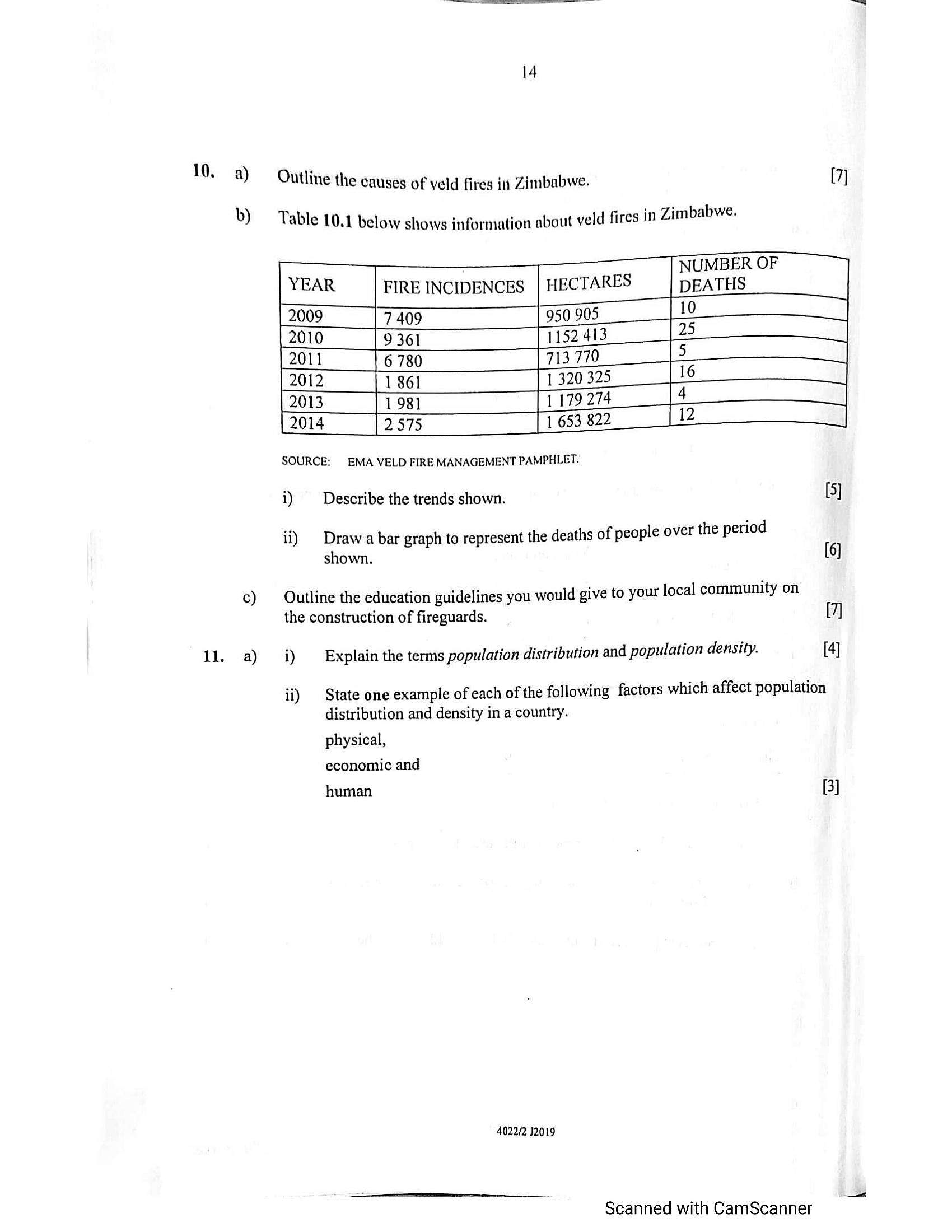
Outline the causes of veld fires int Zimbabwe. [7]b) Table 10.1 below shows information about veld fires in Zimbabwe.
NUMBER OF
FIRE INCIDENCES | HECTARES DEATHS
7409 950 905
9361 1152 413
6 780 713 770
| 1861 1 320 325
| 1981 1 179 274
[2.575 1 653 822
SOURCE: EMA VELD FIRE MANAGEMENT PAMPHLET.
i) Describe the trends shown. [5]
ii) Draw a bar graph to represent the deaths of people over the period
shown. (6)
c) Outline the education guidelines you would give to your local community on
the construction of fireguards. [7]
11. a) i) Explain the terms population distribution and population density. [4]
ii) State one example of each of the following factors which affect population
distribution and density in a country.
physical,
economic and
human
B]
4022/2 J2019
Scanned with CamScanner
---
Page 16
Extracted Text
15b) i) — Draw the structure of any one of the urban landuse models. (5]
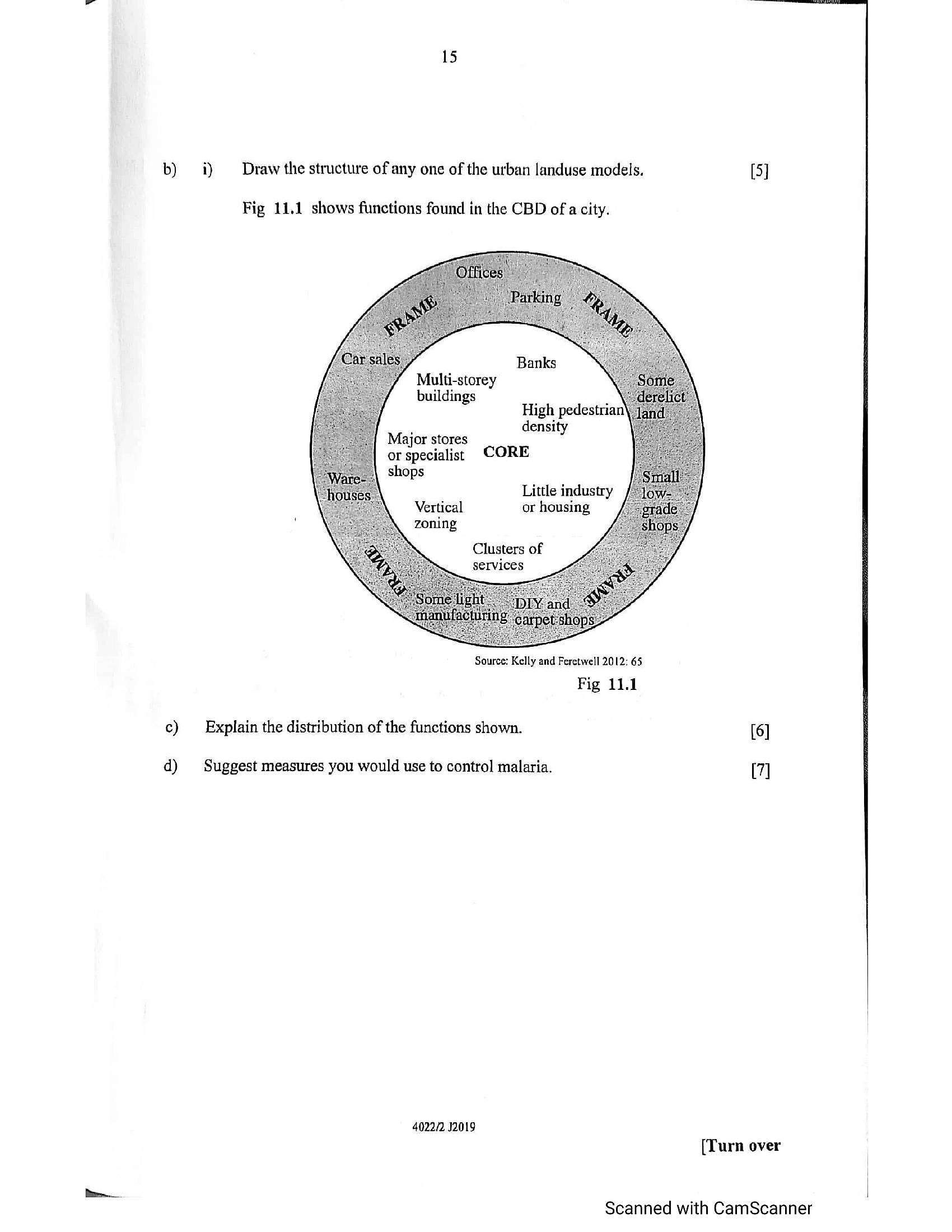
Fig 11.1 shows functions found in the CBD of a city.
Banks
Multi-storey
buildings
High pedestria
, density
Major stores
or specialist CORE
shops
Little industry
Vertical or housing
zoning
Clusters of
services
Source: Kelly and Feretwell 2012: 65
Fig 11.1
c) Explain the distribution of the functions shown. [6]
d) Suggest measures you would use to control malaria. (7]
4022/2. 12019
[Turn over
Scanned with CamScanner
---
Page 17
Extracted Text
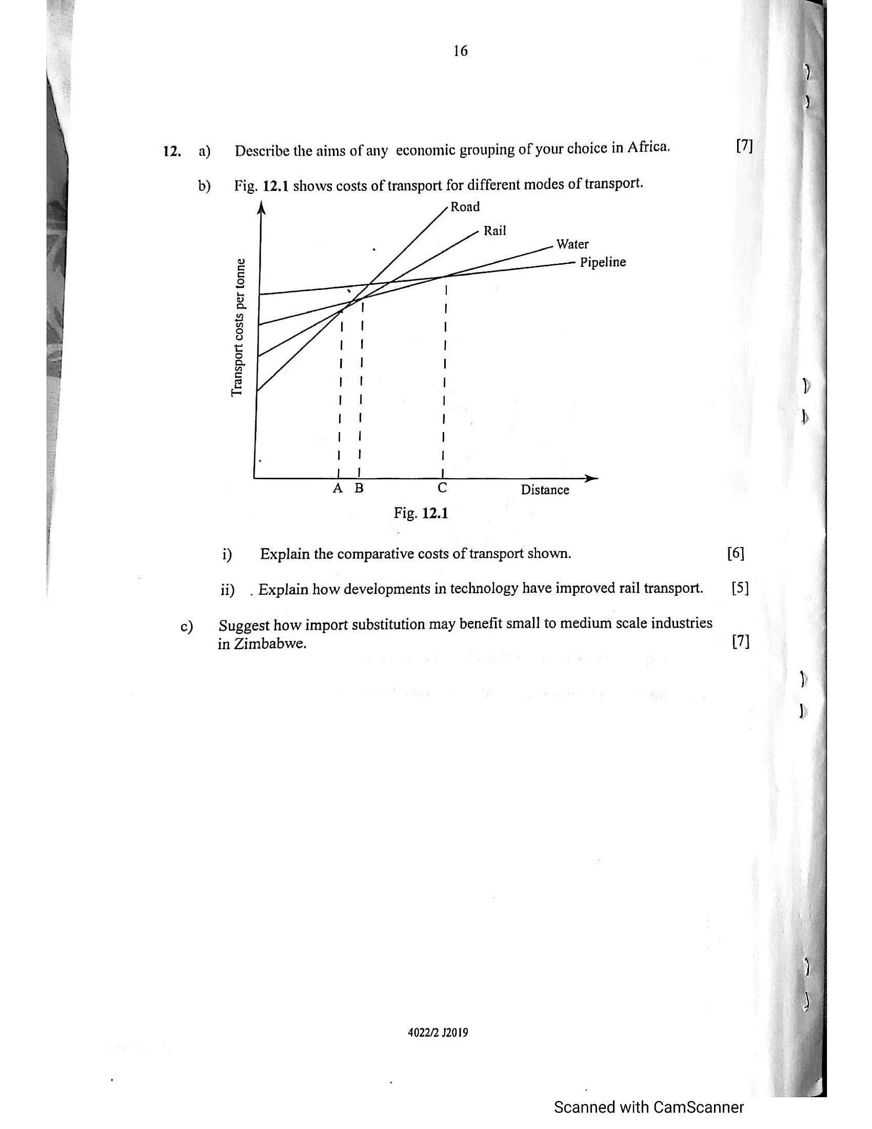
12, a) Describe the aims of any economic grouping of your choice in Africa.b) Fig. 12.1 shows costs of transport for different modes of transport.
Water
Pipeline
Transport costs per tonne
i A Cc Distance
: Fig. 12.1
i) Explain the comparative costs of transport shown. [6]
ii) . Explain how developments in technology have improved rail transport. _—_[5]
Suggest how import substitution may benefit small to medium scale industries
in Zimbabwe.
c)
[7]
4022/2 J2019
Scanned with CamScanner
---
Struggling with the concepts in this paper?
Revise syllabus notes, key exam points, and interactive practice questions for Geography: