📄 Exam Questions & Readable Text Transcript
Full OCR-extracted text of questions, syllabus codes, and exam instructions.
Extracted Content: 2018_geo_olevel_nov_paper2
Page 1
Extracted Text
Te Rafrrmanes MoeanenmentZIMBABWE SCHOOL EXAMINATIONS COUNCIL
General Certificate of Education Ordinary Level
GEOGRAPHY 4022/2
PAPER 2
2 hours 30 minutes
NOVEMBER 2018 SESSION
Additional materials:
Answer paper
INSTRUCTIONS TO CANDIDATES
Write your name, centre number and candidate number in the spaces provided on the answer
paper/answer booklet.
Answer four questions. Answer one question from each of sections A, B and C and one other
from any section.
Write your answers on the separate answer paper provided. If you use more than one sheet of
paper, fasten the sheets together,
INFORMATION FOR CANDIDATES
The number of marks is given in brackets [ ] at the end of each question or part question.
Sketch maps and diagrams should be drawn whenever they serve to illustrate an answer.
Thic anactian nanar sancicte af 12 nrinted nacec and 3 hlank nage(s).
---
Page 2
Extracted Text
Section A (Physical Environment)Answer at least one question from this section
1. a) i) Describe the formation of a rift valley,
ii) State any two landforms associated with rift valleys.
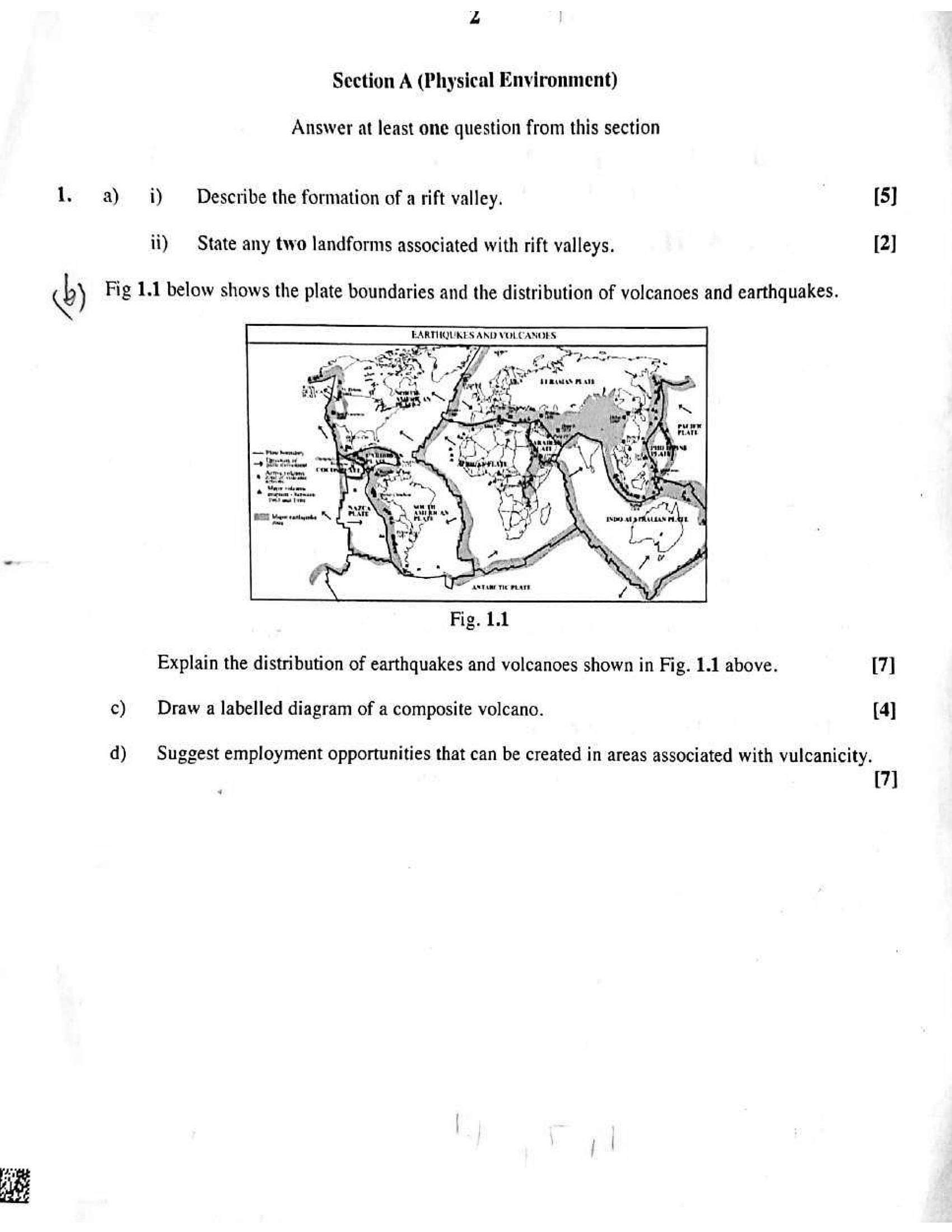
) Fig 1.1 below shows the plate boundaries and the distribution of volcanoes and earthquakes.
7
oes
sre ue
PERN
iste xt prAALLAN whe
. je
Rm, LY
Se
Fig. 1.1
Explain the distribution of earthquakes and volcanoes shown in Fig. 1.1 above.
c) Draw a labelled diagram of a composite volcano.
d) Suggest employment opportunities that can be created in areas associated with vulcanicity.
4
[5]
[2]
[7]
[4]
(7]
---
Page 3
Extracted Text
w2. a) i) State any two conditions necessary for cloud formation. [2]
ii) Describe the characteristics of a cumulonimbus cloud and the weather associated
with it. [5]
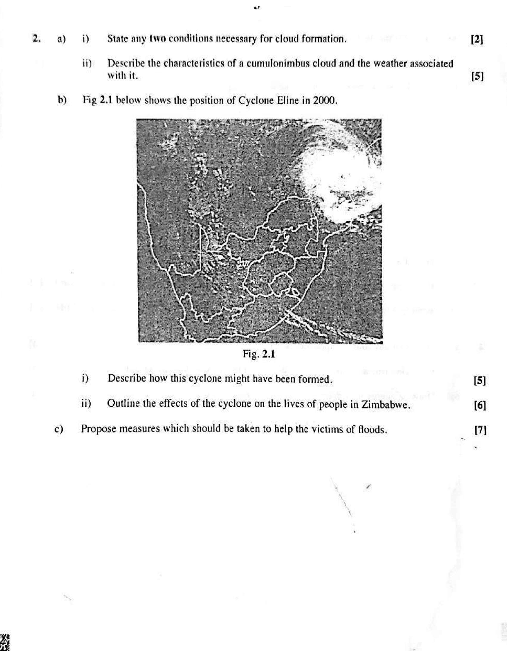
b) Fig 2.1 below shows the position of Cyclone Eline in 2000.
i) Describe how this cyclone might have been formed. [5]
ii) Outline the effects of the cyclone on the lives of people in Zimbabwe. [6]
c) | Propose measures which should be taken to help the victims of floods. [7]
---
Page 4
Extracted Text
3.a)
b)
c)
a)
b)
i) Define the Global Positioning System (GPS),
ii) Identify any four Global Positioning System (GPS) receivers.
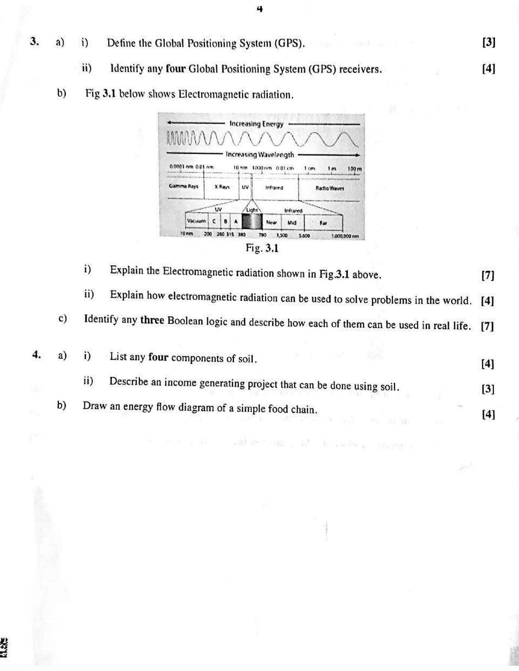
Fig 3.1 below shows Electromagnetic radiation,
———— Increasing Energy
WA WS wl rs I \ SG
Increasing Wavelength
1
8.0001 am wen 0) fry : 1am aes GOL em Mia 109m
- 4 —aae
~<a 4 v | Infrared
a “Ww
Vaca | c a A wie va Far
fOnm = 2) 2803S ede TROL ND
Fig. 3.1
i) Explain the Electromagnetic radiation shown in Fig.3.1 above.
ii) Explain how electromagnetic radiation can be used to solve problems in the world.
Identify any three Boolean logic and describe how each of them can be used in real life.
i) List any four components of soil.
ii) Describe an income generating project that can be done using soil.
Draw an energy flow diagram of a simple food chain.
[3]
[4]
[7]
[4]
[7]
[4]
[3]
[4]
---
Page 5
Extracted Text
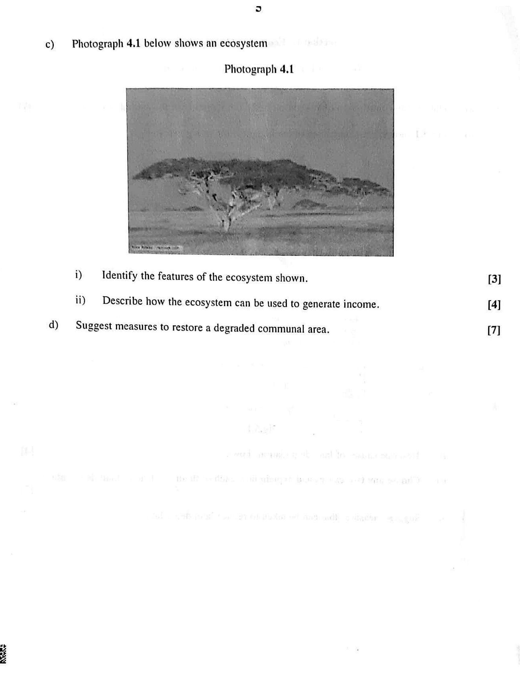
c) Photograph 4.1 below shows an ecosystemPhotograph 4.1
i) Identify the features of the ecosystem shown. [3]
ii) Describe how the ecosystem can be used to generate income. [4]
d) Suggest measures to restore a degraded communal area. [7]
---
Page 6
Extracted Text
Section B (Economic Geography); j ion
Answer at least one question from this sectio!
ion i natural environment. [7
5. a) Outline the contribution of vegetation in the conservation of the 1
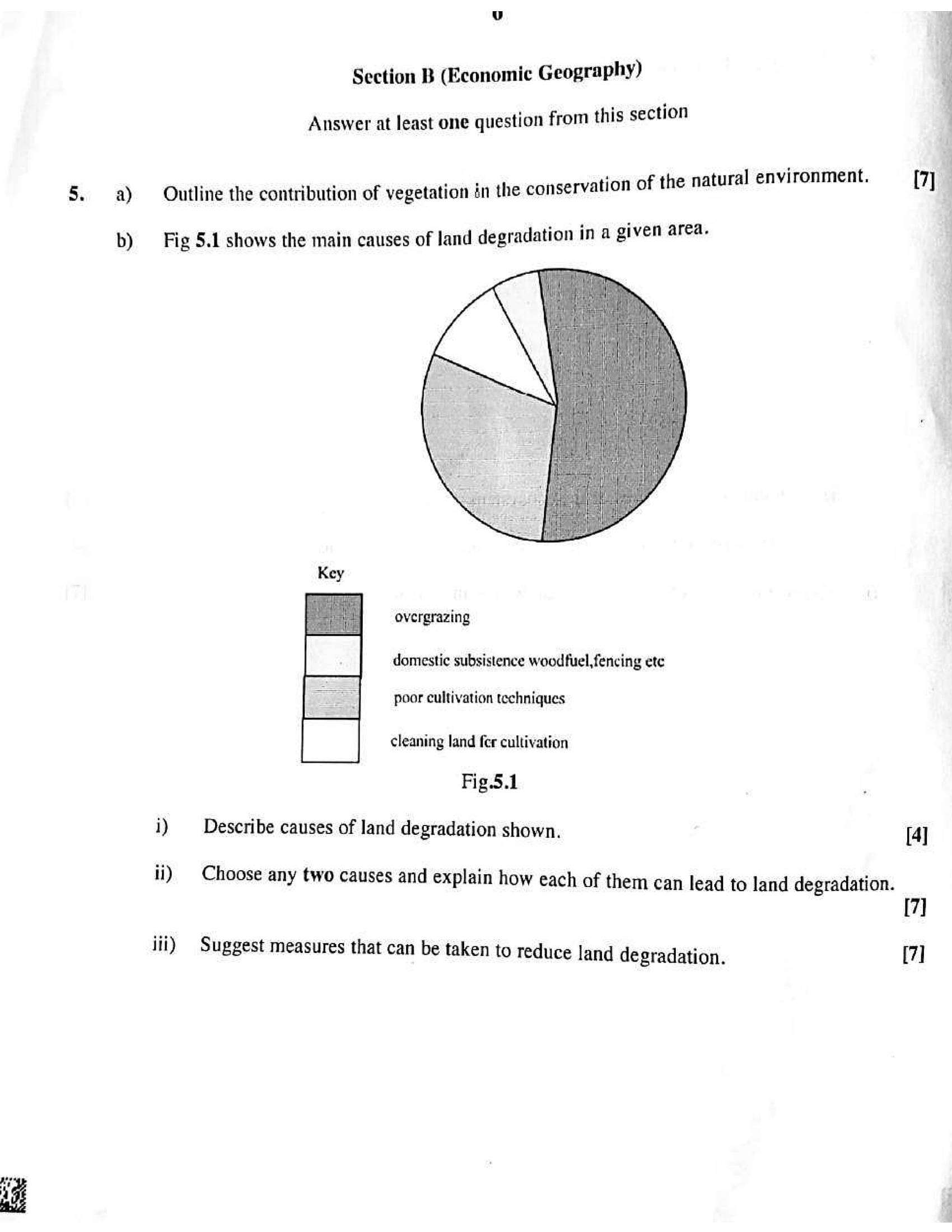
b) Fig 5.1 shows the main causes of land degradation in a given area.
overgrazing
domestic subsistence woodfuel,fencing ete
poor cultivation techniques
cleaning land fer cultivation
Fig.5.1
i) Describe causes of land degradation shown. [4]
ii) _ Choose any two causes and explain how each of them can lead to land degradation.
7]
iii) Suggest measures that can be taken to reduce land degradation. [7]
---
Page 7
Extracted Text
Rebar6. a)
b)
c)
With reference to Zimbabwe, outline the importance of mining to its economy.
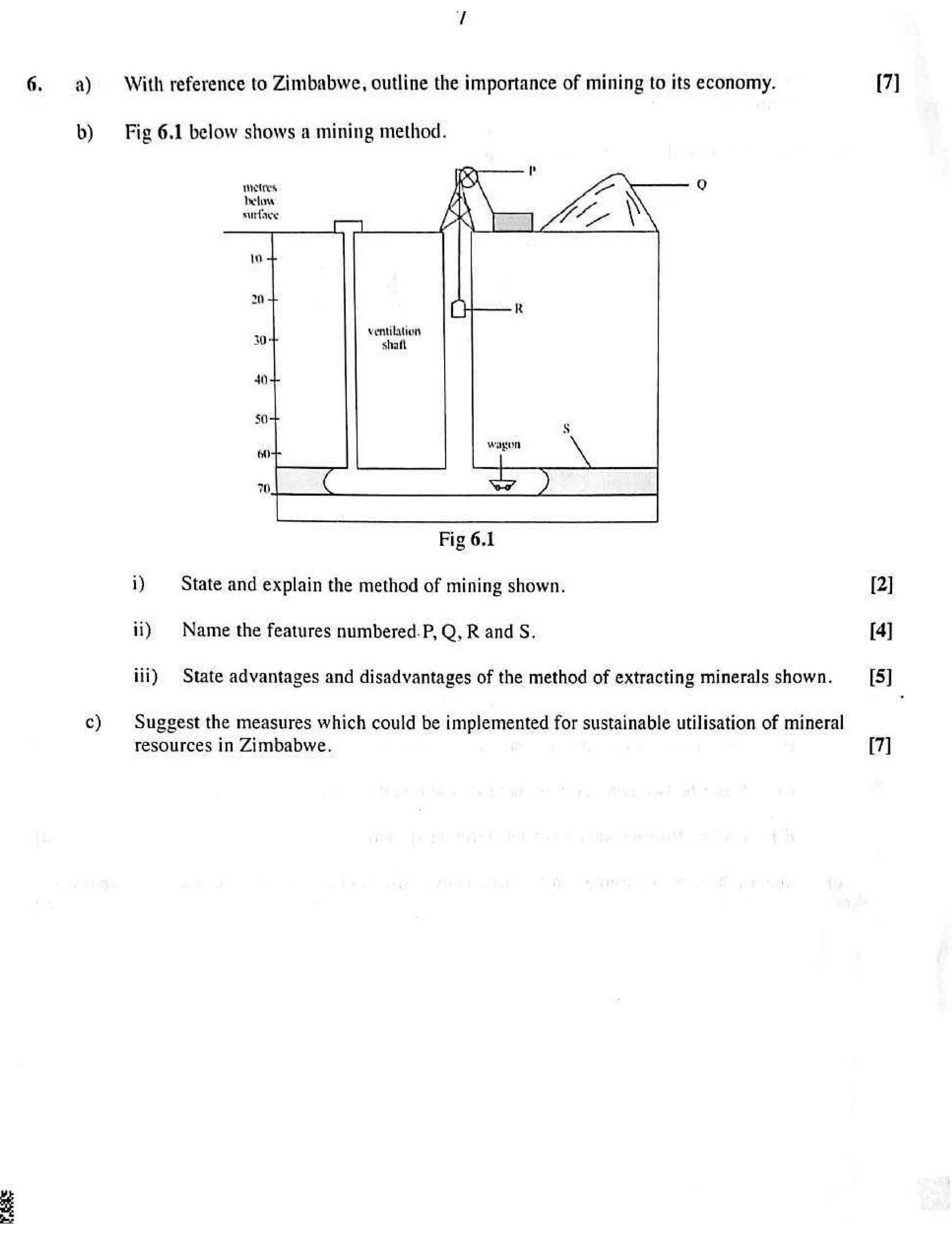
Fig 6.1 below shows a mining method.
metres
below
surface
ventilation
shaft
nf
wagon
Fig 6.1
i) State and explain the method of mining shown.
ii) Name the features numbered. P, Q, R and S.
iii) State advantages and disadvantages of the method of extracting minerals shown.
Suggest the measures which could be implemented for sustainable utilisation of mineral
resources in Zimbabwe.
[7]
[2]
[4]
[5]
[7]
---
Page 8
Extracted Text
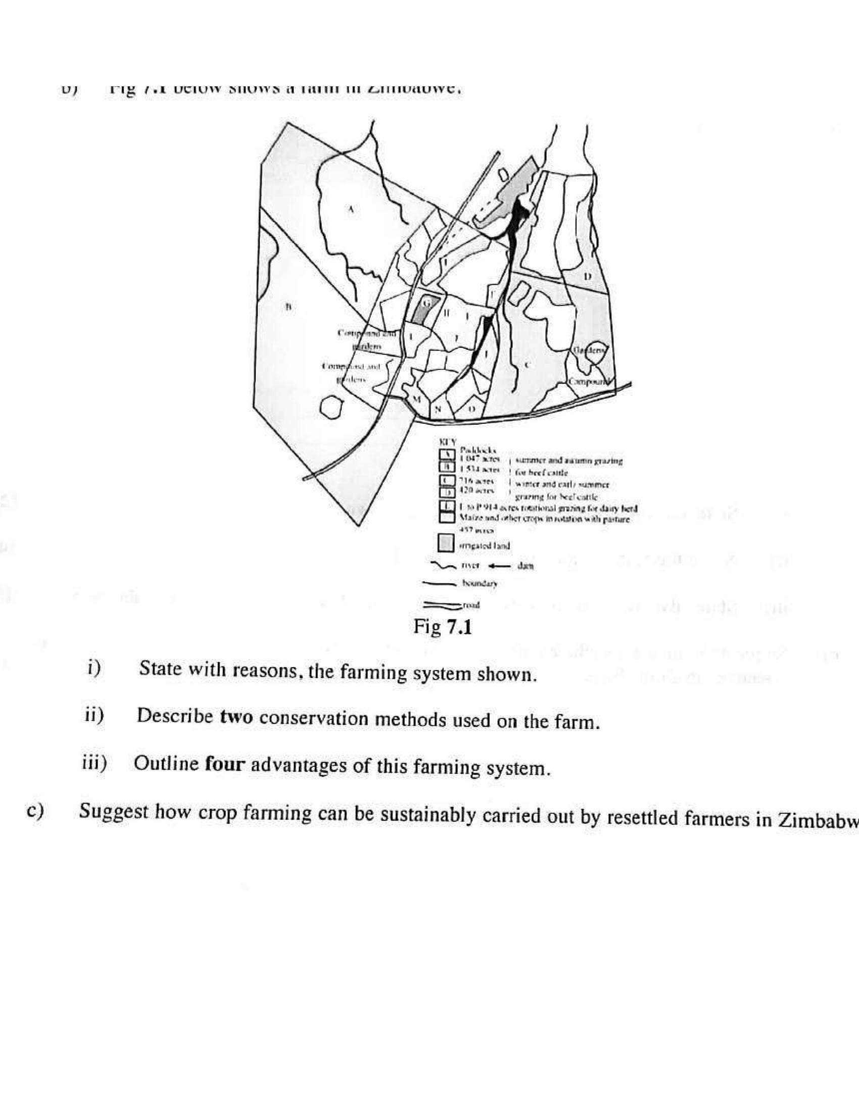
c)vu) rig fel UCIUW STMUW)S i LTT Ti ZotuaUuwe,
Paldacks
al VOT cre | sutrmmter aad autem grazing
{Sd ater | fw beef caite
A Tiare | wamter and eagly summer
12M oar) craving lor heel catit
4 1 50-19 914 ores tomutionsl grazing for dairy herd
Maize und other cro in nation with pasture
297 wren
oO wrrigatest tamd
NAc ae den
~~ thnindary
rel
Fig 7.1
i) State with reasons, the farming system shown.
ii) Describe two conservation methods used on the farm.
iii) Outline four advantages of this farming system.
Suggest how crop farming can be sustainably carried out by resettled farmers in Zimbabw
---
Page 9
Extracted Text
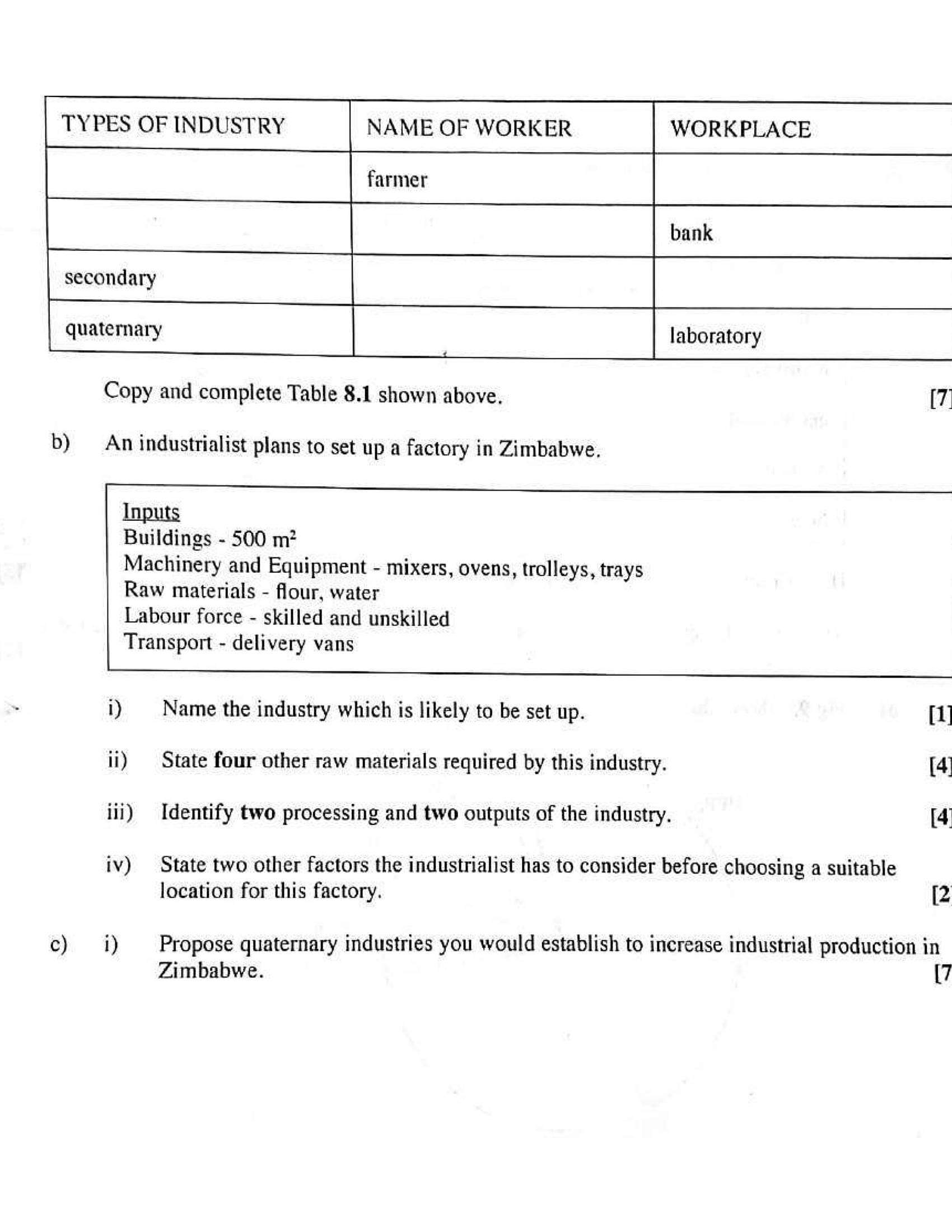
WORKPLACETYPES OF INDUSTRY NAME OF WORKER
a
quaternary laboratory
Copy and complete Table 8.1 shown above, [7
b) An industrialist plans to set up a factory in Zimbabwe,
Inputs
Buildings - 500 m?
Machinery and Equipment - mixers, ovens, trolleys, trays
Raw materials - flour, water
Labour force - skilled and unskilled
Transport - delivery vans
i) | Name the industry which is likely to be set up. [i]
ii) | State four other raw materials required by this industry. [4
iii) Identify two processing and two outputs of the industry. [4
iv) State two other factors the industrialist has to consider before choosing a suitable
location for this factory. [2
c) i) Propose quaternary industries you would establish to increase industrial production in
Zimbabwe. {7
---
Page 10
Extracted Text
a)b)
CNR WE ee ewe wee ape
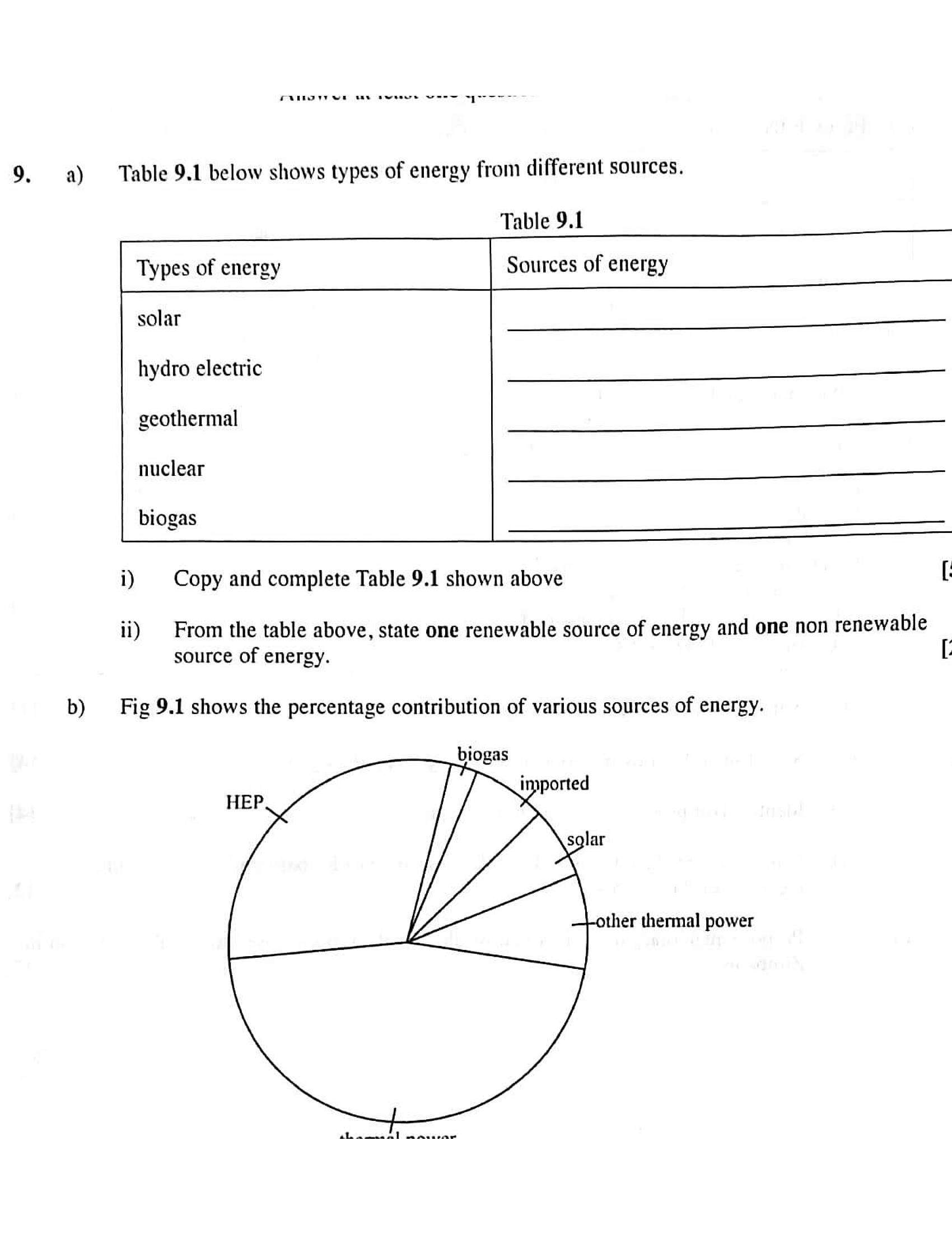
Table 9.1 below shows types of energy from different sources.
Table 9.1
Types of energy Sources of energy
solar
hydro electric
geothermal
nuclear
biogas
i) | Copy and complete Table 9.1 shown above [
ii) From the table above, state one renewable source of energy and one non renewable
source of energy. [:
Fig 9.1 shows the percentage contribution of various sources of energy.
ther thermal power
---
Page 11
Extracted Text
power. [4c) Suggest measures to improve availability of energy in your local area. [7
a) i) Explain the meaning of Environmental Impact Assessment (EIA) [2
ii) Fora large scale dam project, outline the information you would include in your a
report.
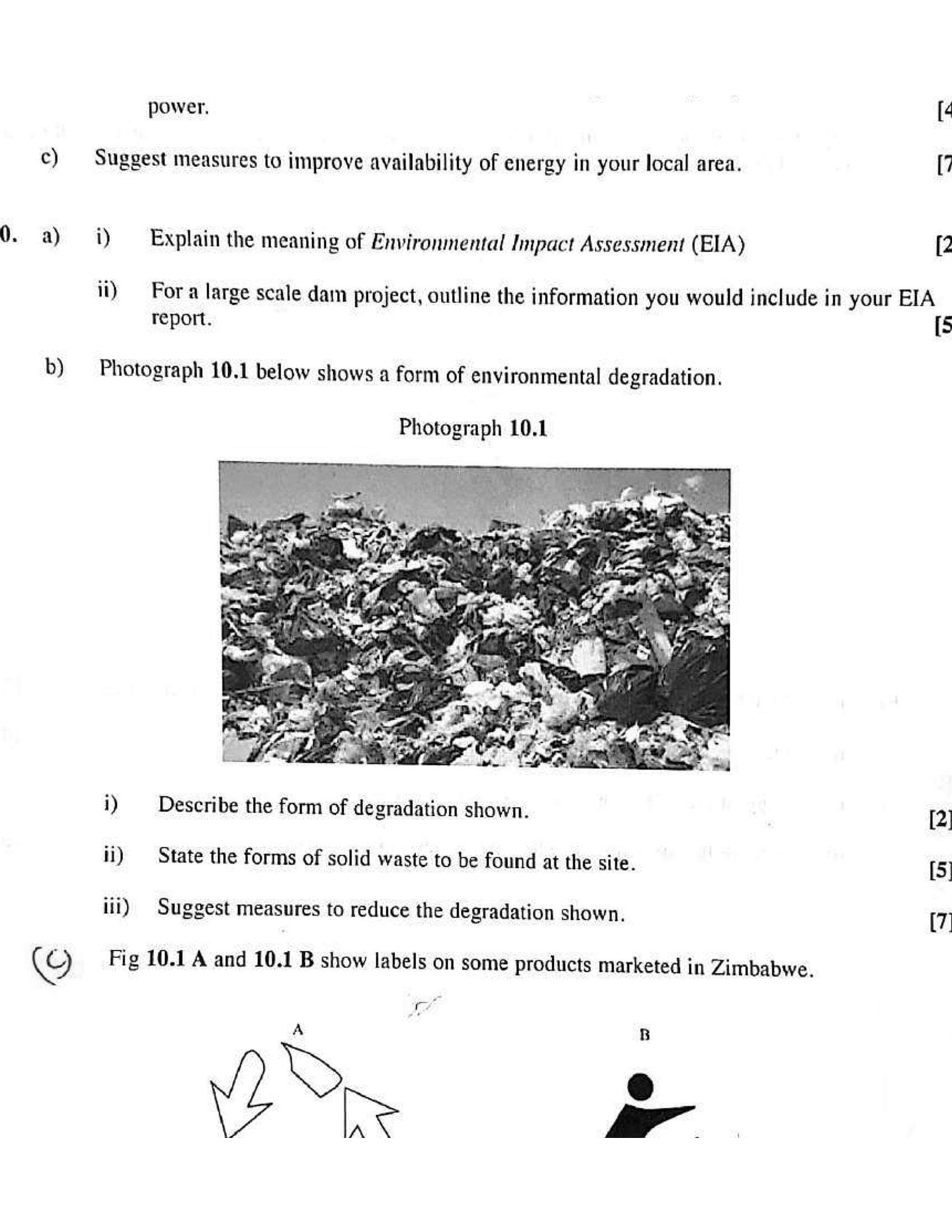
b) Photograph 10.1 below shows a form of environmental degradation.
Photograph 10.1
i) Describe the form of degradation shown. [2]
ii) State the forms of solid waste to be found at the site. [5)
iii) Suggest measures to reduce the degradation shown, (7)
iC) Fig 10.1 A and 10.1 B show labels on some products marketed in Zimbabwe.
ay
A B
© :
he | a
---
Page 12
Extracted Text
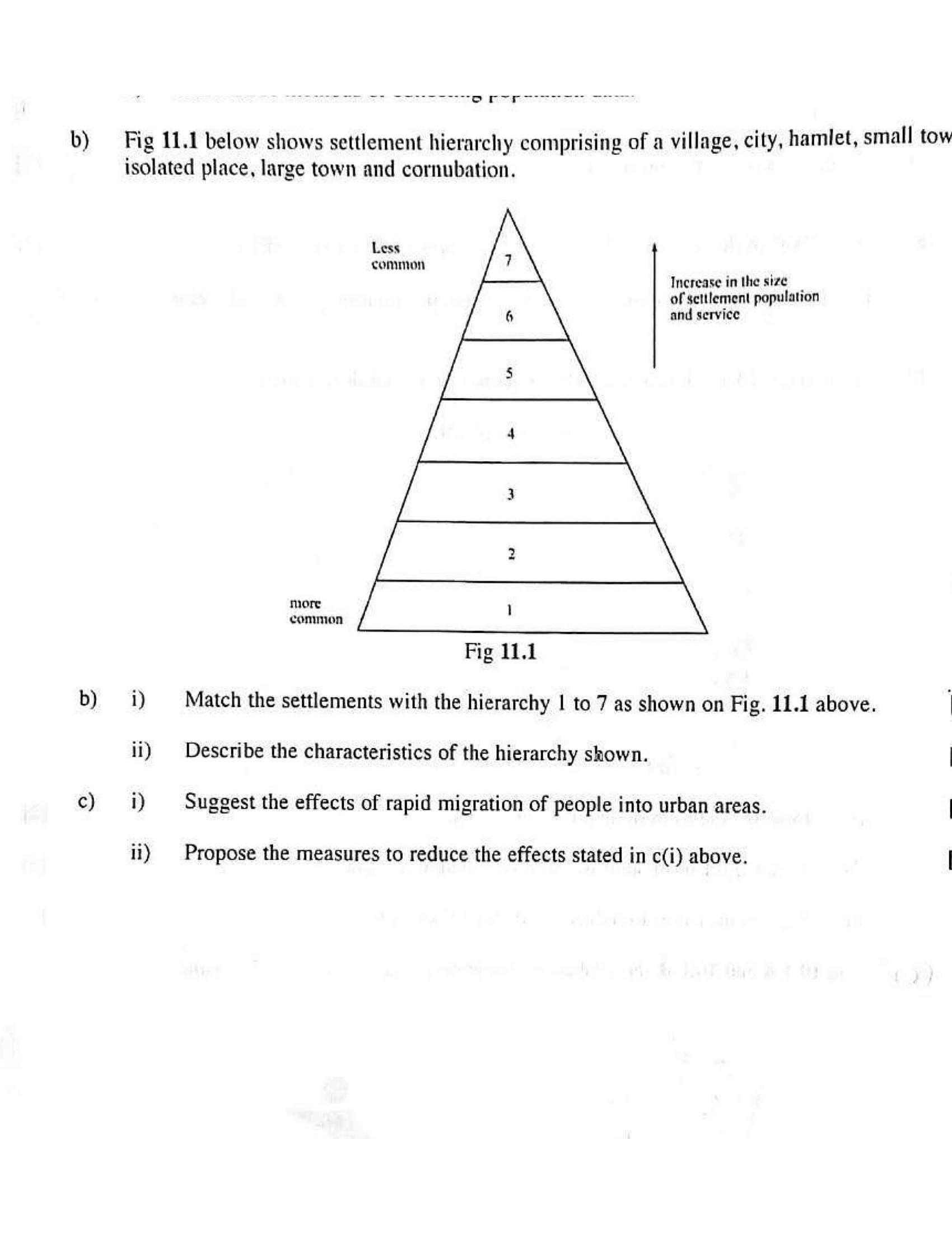
TR TO RGD. BR ACO eee on eel haventb) _ Fig 11.1 below shows settlement hierarchy comprising of a village, city, hamlet, small tow
isolated place, large town and cornubation.
Less
common
Increase inthe size
of settlement population
and serviee
more
common
Fig 11.1
b) i) Match the settlements with the hierarchy | to 7 as shown on Fig. 11.1 above.
ii) Describe the characteristics of the hierarchy shown. |
¢) i) Suggest the effects of rapid migration of people into urban areas. |
ii) | Propose the measures to reduce the effects stated in c(i) above. |
---
Page 13
Extracted Text
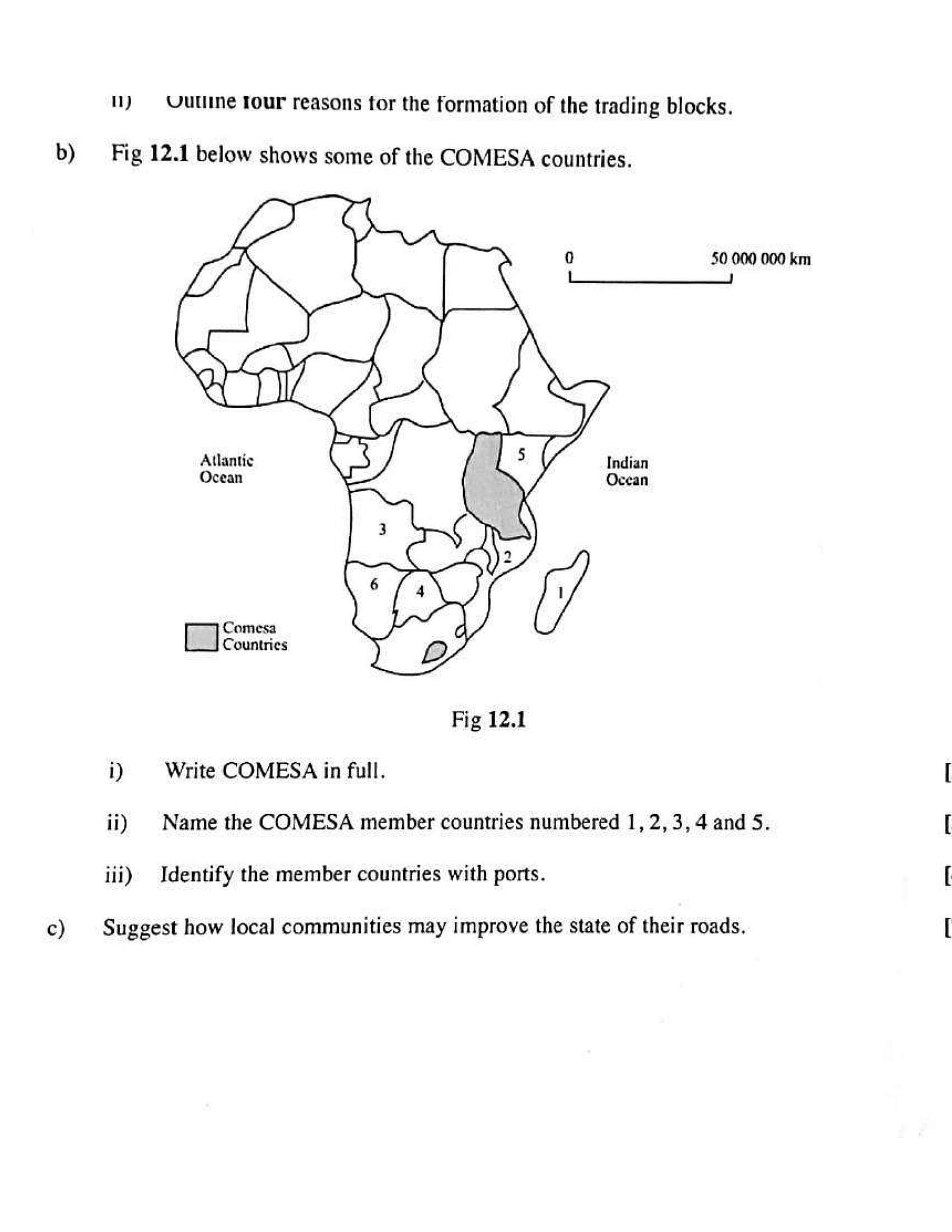
1) Uulline Tour reasons for the formation of the trading blocks.b) Fig 12.1 below shows some of the COMESA countries.
50 000 000 km
Atlantic
Ocean
Comesa
Countries
Fig 12.1
i) Write COMESA in full.
ii) | Name the COMESA member countries numbered 1, 2,3, 4 and 5.
iii) Identify the member countries with ports.
c) Suggest how local communities may improve the state of their roads.
---
Struggling with the concepts in this paper?
Revise syllabus notes, key exam points, and interactive practice questions for Geography: